


FECORE – Bungled 12-km Lake Balaton (Hungary) laser test 2018
Dear Readers,
Update: August 2019:
The truth finally comes out of Mike Cavanaugh validating all we have said in this and our other articles on the FECORE laser test.
As Mike Cavanaugh finally explains in this August 2019 interview with Sly Sparkane, the goal of the laser test was to hit the distance target. Nothing else.
Our note: That does not prove the earth is flat. The laser can be aimed up/down and left/right. Point it above the horizon line any way you want just to get the laser light seen at the target location.
Aimed and traveling over the horizon the laser beam is refracted by the atmosphere and subject to other thermal distortions, before its ever widening beam (laser beam divergence) makes it to the distant target.
This only proved that the laser was bright enough to be seen from those distances. Nothing else.
Sly Sparkane says,
“What was the ultimate goal of the test? Was it to see the laser at the other end or was it to hit a target?”
Mike Cavanaugh says,
"to hit a target..."
Sly Sparkane says,
“and did you hit a target…”
Mike Cavanaugh says
“yes…”
Sly Sparkane says
“at 22 kilometers?”
Mike Cavanaugh says,
“at 20 and 26 or 27 or 29 now…”
This is FECore (MIRRORED), by Flat Earth Reset 3
https://www.youtube.com/watch?v=V67XR5Xkhd8
Update: October 2019:
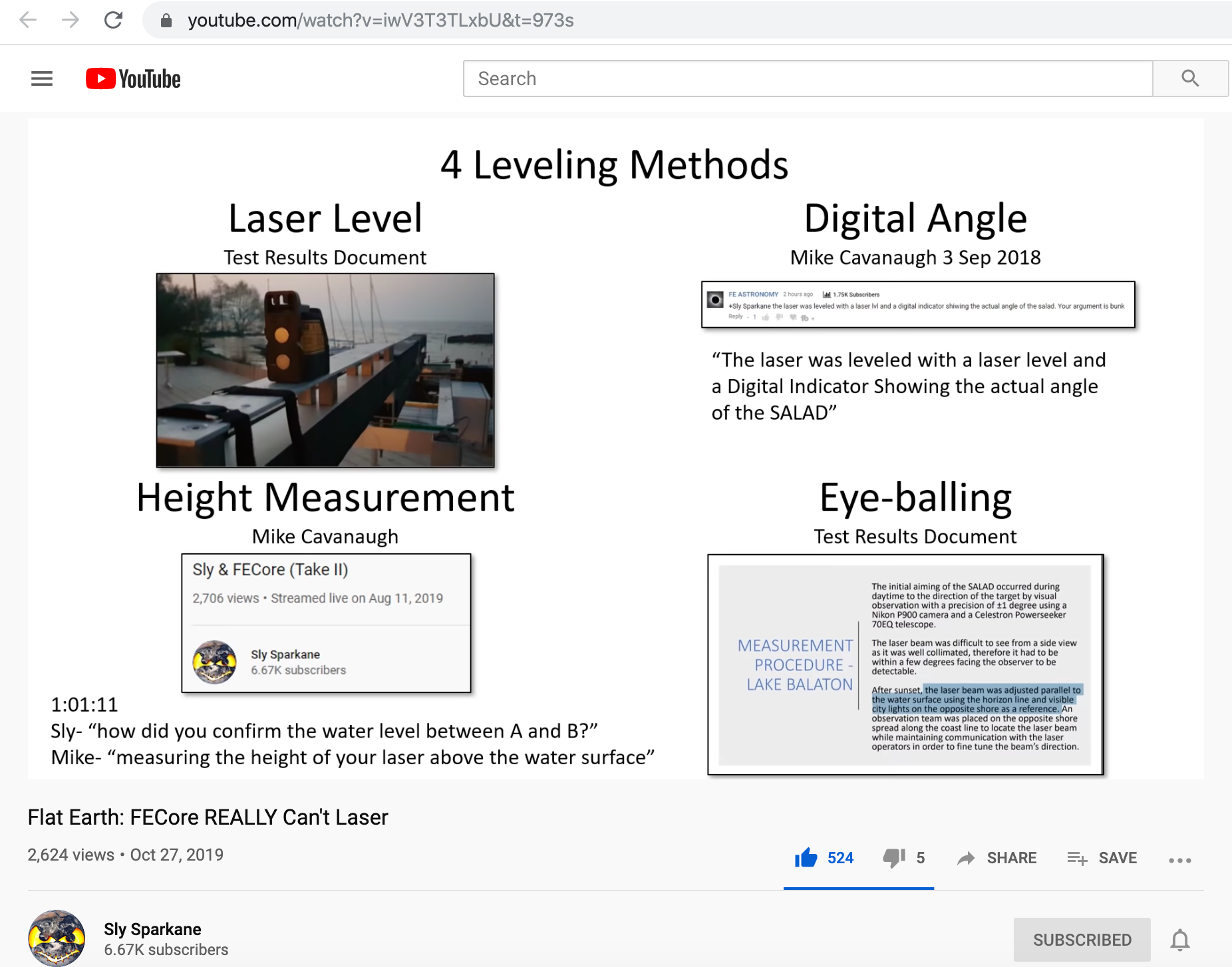
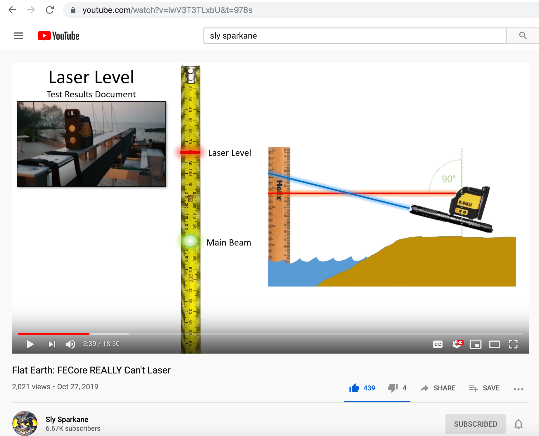
The following video by Sly Sparkane validates the main xx points that we presented 18-months ago.
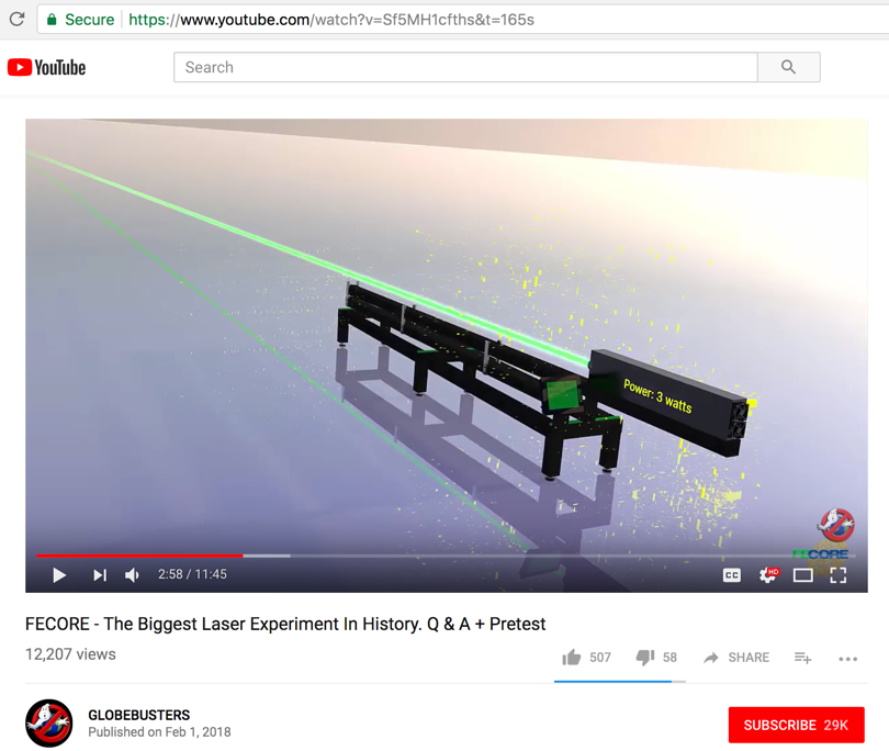
Flat Earth: FECore REALLY Can'r Laser, by Sly Sparkane
https://www.youtube.com/watch?v=iwV3T3TLxbU&t=973s
-
-
-

* * * * * * * * * * * * * * * * * * * * * * * * * * * * * * * * * * * * * * * * * * * * * * * * * * * * * * * * * * * * * * * * * * * * * * * * * * * * * * * * *
* Supplemental reading after this article
* FECORE 2018 - Lake Balaton and Lake Ijssel laser test - PEER REVIEW
* https://flatearthlunacy.com/index.php/2-uncategorised/932-fecore-2018-lake-balaton-and-lake-ijssel-laser-test-peer-review
*
* * * * * * * * * * * * * * * * * * * * * * * * * * * * * * * * * * * * * * * * * * * * * * * * * * * * * * * * * * * * * * * * * * * * * * * * * * * * * * * * *
- - - - - - - - - - - - - - - - - - - - - - - - - - - - - - - - - - - - - - - - - - - - - - - - - - - - - - - - - - - - - - - - - - - - - - - - - - - - - - - - - - - - - - -
Published on – May 11, 2018
FECORE – Bungled 12-km Lake Balaton (Hungary) laser test 2018.
Read here how sloppy and inept experimentalists came up with erroneous and incorrect conclusions. We highlight the errors in their own published document.
FECORE just published their 118-page official research document that goes over their Lake Balaton (Hungary) laser test 2018.
We found several errors and misinterpretations of data in the document. They failed to prove that the Earth is not curved.
Please read our evaluation listed below...
- -
Abstract:
The FECORE team did not attempt to prove that the Earth is flat at Lake Balaton.
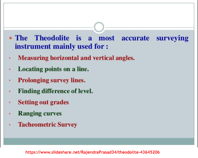
During the entire course of the experiment they did not use any of the standard Geodetic survey tools; such as an internationally approved Theodolite/Auto level, GPS tracker, level staff, ranging rod, retro-reflector and surveyor’s tripod.
They did not place level staffs or sighting targets at various marker points along the Lake Balaton shoreline, to demonstration progressive tracking of Earth flatness over length.
They did not stake laser reflectors at various locations along the shoreline, and target them with a laser beam to demonstrate that the beam is truly pointed parallel to the water's surface over distance. That is a primary requirement to corroborate flatness.
The FECORE team did however, attempt thru a single measurement, to imply "proof by contradiction."
Proof by contradiction is a form of indirect proof, that establishes the truth or validity of a proposition. It starts by assuming that the opposite proposition is true, and then shows that such an assumption leads to a contradiction.
The error in this type of approach is the "assumption" that the Earth can only have two possible valid shapes - either flat or spherical. Attempting to prove that the Earth is not spherical, does not authenticate that the Earth is flat. And other flat Earth supporters willingly testify that the Earth is concave, convex, or undoubtedly a flat plane with as yet unmeasured total dimensions.
The shore-to-shore laser test should not have been wrapped up at the 12-km distance mark. Data at 12-km is not conclusive. That is around the FUZZY distance where, a) optical refraction, b) no precise measurements of source and target height above the water line, and c) no exact distance between source and target established - create a situation where a few meters can be argued about back and forth.
But that is what they delivered, and why their claim will forever be in dispute.
To definitively prove flatness shore-to-shore measurements at 20-km, 30-km, 40-km, 50-km, 60-km and further are required. But FECORE did not render that.
Major error found:
Busted - Based on the elevation measurement that Google Earth Pro provides (via most accurate WGS 84 datum), and their location coordinates (latitude & longitude),
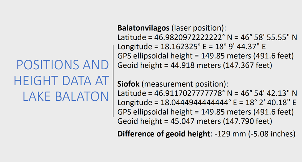
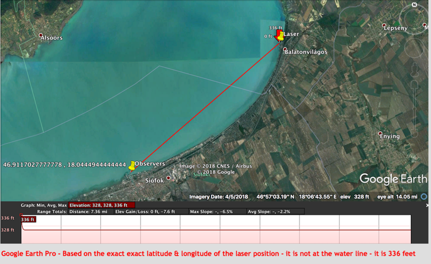
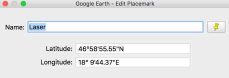
Balatonvilagos test position:
Latitude = North 46o 58’ 55.55” or 46.9820972222222o
Longitude = East 18o 9’ 44.37” or 18.162325o
Elevation above sea level per WGS 84 datum = 336 feet
This position is already 8-feet above the Lake Balaton water level line, not at the water level as they claim.
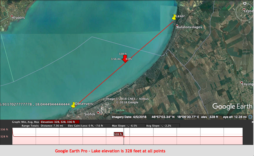
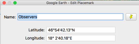
Siofok test position:
Latitude = North 46o 54’ 42.13” or 46.9117027777778o
Longitude = East 18o 2’ 40.18” or 18.0444944444444o
Site elevation above sea level per WGS 84 datum = 328 feet
Lake Balaton elevation above sea level per GPS/Google Earth/WGS 84 datum = 328 feet
... the real elevation of the BLUE laser at Balatonvilagos for the 12-km test is 336-feet plus tripod length above sea level.
That is 336 - 328 = 8 feet above the Lake Balaton water line.
NOT THE the 4.92 feet (1.5 meters) that FECORE claimed and used for their curved earth calculations.
Actual BLUE laser height above the water line is (8 + 4.92) = 12.92 feet
See “Lake Balaton Discrepancy 3:” listed below.
Major logical fallacy:
GPS uses satellites that all other flat Earth proponents insist do not exist. Yet the FECORE team accepted the GPS, Google Earth and WGS 84 map datum in order to establish location, separation distance, and elevation of their laser and observers for calculations. Then later they claim (see below) that the WGS 84 datum is wrong and the Earth is flat. That is a major contradiction of logic (you can't have it both ways) and casts doubt on their entire experiment.
FECORE document is here:
https://onedrive.live.com/?authkey=%21AKqnM8CLz15joeg&id=EE4552DBA7C55E9F%21119&cid=EE4552DBA7C55E9F
- -
Lake Balaton Discrepancy 1:
The following advertised goals were all missed:
=> The World's First, A Test Like No Other
=> The Most Sophisticated Long Distance Laser Experiment in History
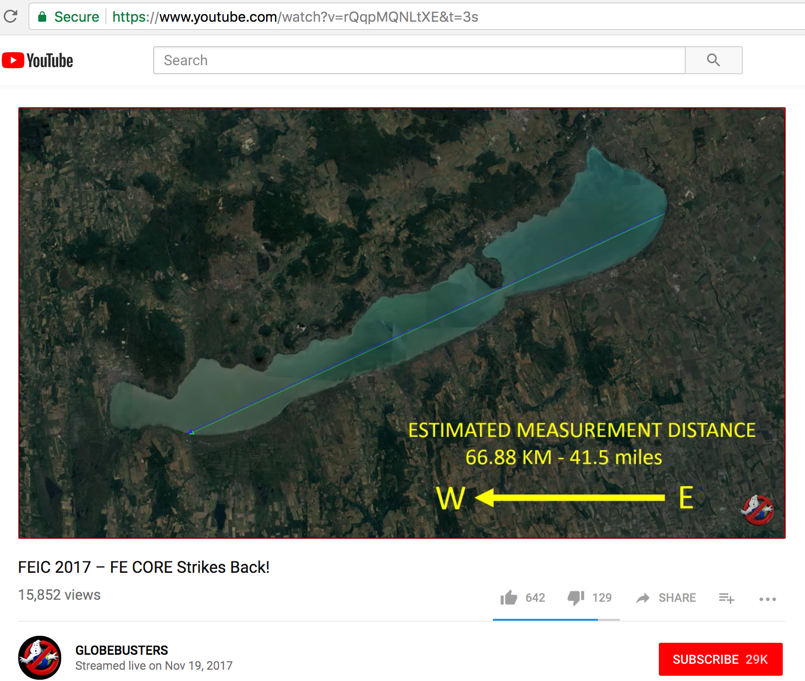
FECORE declares success with their 12-km Lake Balaton test (not 67-km as advertised).
Or, how to disguise failure as success.
- -
Lake Balaton Discrepancy 2:
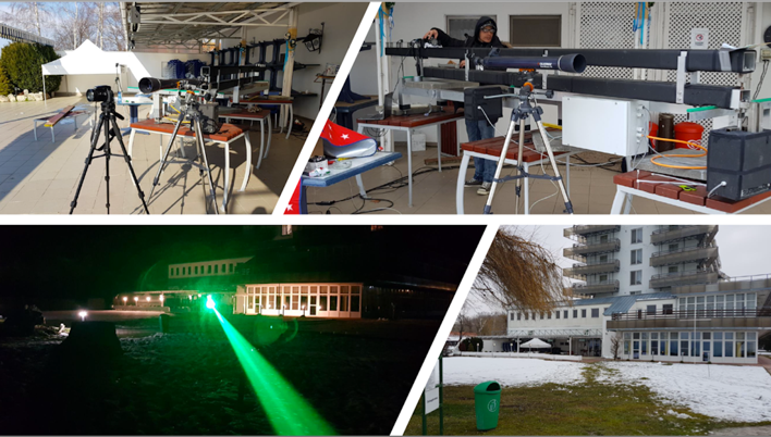
The much advertised SALAD (Super Accurate Laser Aiming Device, their own made up name) green laser was not used for the Lake Balaton 12-km test because they broke it beforehand. It was very cold - so they used a heating blanket to warm up the laser and some lenses cracked.
Note: The SALAD device did not have GPS aiming enhancement at this time.
& FECore (Take II) - https://www.youtube.com/watch?v=7dQjB1VQUG4
They mounted that laser on a rail system that could (as they claim) be aimed accurately (up, down, right & left). They also claim that software changes allow them to point the laser directly at a distance location - based on latitude & longitude.
The laser system itself does not have auto-horizon leveling capability, as do surveying Theodolites and simple Dumpy Levels.
But that's not all...
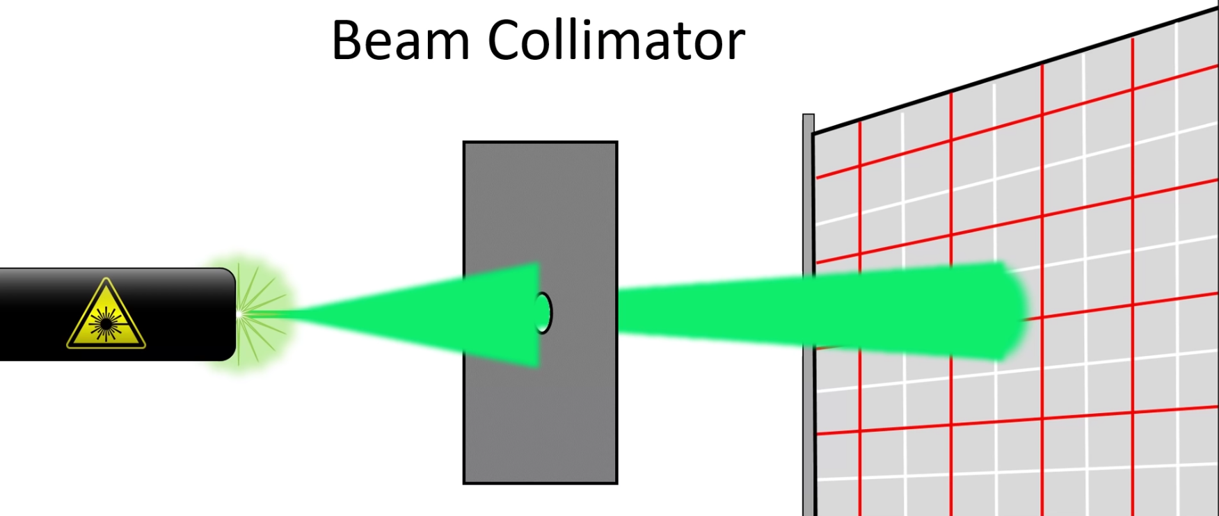
No automatic or accurate instrumentation measurement or guarantee at what height the laser beam is actually above the water line. And even with its laser collimators the beam still does not remain pencil thin over distance.
-
This green laser never left the terrace of the Waberer's Club Hotel. It was never placed in the water as promised and shown below.
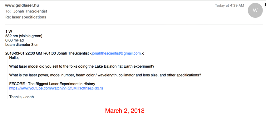
They advertised that this was a 3-watt laser. But in reality they only bought a 1-watt green laser from goldlaser.hu, as confirmed by our email from them listed below.
Goldlaser.hu specializes in lasers for light shows.
This green SALAD laser was test fired from the terrace (as shown below) before the actual 12-km experiment day.
Mounted on rails it's heavy and not easy to move.
The Hotel terrace is many meters above Lake Balaton's water line level.
Lake Balaton Discrepancy 3:
We found the big mistake that invalidates the conclusions they reached in the 12-km test.
Here we will now show, based on the data in their document, that they made mistakes and how that led them to incorrect experiment conclusions.
Here are the two defined locations; a) where the BLUE laser is, and b) where the observers are.
Based on the latitude & longitude of both positions (Balatonvilagos & Siofok) as they hereby supplied...
According to Google Earth Pro, here both locations are identified...
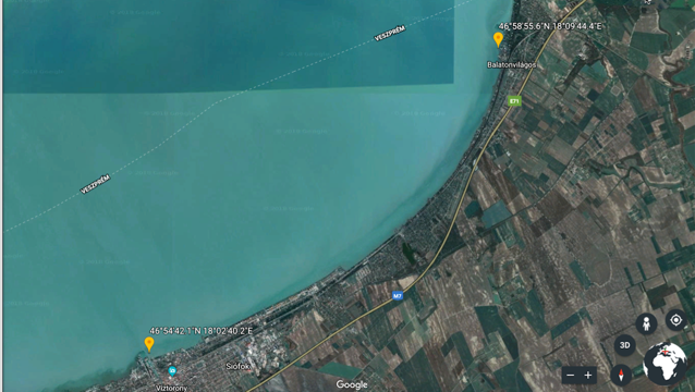
Distance line between both sites...
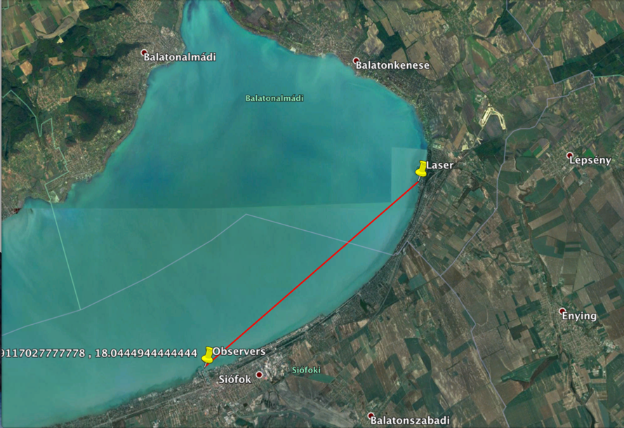
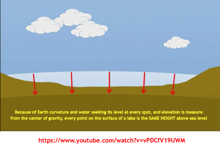
Lake Balaton is 328-feet consistently above sea level, from shore to shore.
That's because over distance water curves to follow the shape of the Earth, since the center of gravity always points directly downward at all locations.
Major error found:
Based on the height measurement that Google Earth Pro provides (via the most accurate WGS 84 datum), the real elevation of the BLUE laser position is 336-feet above sea level plus tripod.
That is 336 - 328 = 8 feet above the water line. Not the 4.92 feet (1.5 meters) that FECORE claimed and used for their curved earth calculations.
This begs the question whether this was an honest mistake or not.
Notice that the laser is positioned on an incline. With 30+ mph winds blowing in that direction and snow accumulating on the incline, it could have been visually mistaken that the water line was closer than it really was. We were not there.
Notice the 336 ft elevation signature on the picture below directly above the laser (yellow-pinned) location, and also on the topological profile at the bottom.
Balatonvilagos test position:
Latitude = North 46o 58’ 55.55” or 46.9820972222222o
Longitude = East 18o 9’ 44.37” or 18.162325o
Elevation above sea level per WGS 84 datum = 336 feet
This position is already 8-feet above the Lake Balaton water level line
Siofok test position:
Latitude = North 46o 54’ 42.13” or 46.9117027777778o
Longitude = East 18o 2’ 40.18” or 18.0444944444444o
Elevation above sea level per WGS 84 datum = 328 feet
Lake Balaton elevation above sea level per GPS/Google Earth/WGS 84 datum = 328 feet
Here are the correct calculations:
Proceeding from the exact latitude & longitude of the laser position given by FECORE, the height of the laser above the water level is:
336 feet (elevation of the laser per Google Map Pro) - 328 feet (lake water level) + 4.92 (1 meter laser tripod additional height) = 12.92 feet above the water line length.
Observer height = 3.8 feet (1.158 meters)
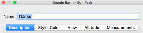
Distance of 11.8 km = 7.33 miles
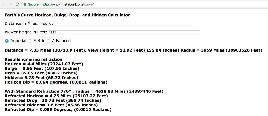
With refraction = hidden amount of 3.8 feet (1.158 meters) which is within 1-foot of the FECORE claim that the laser was seen at 2.79 feet (1.6 meters). That is well within standard deviation and (±) error accuracy.
-
BUT there is good reason to believe that their 2.79 feet (1.6 meters) claim is ALSO not correct...
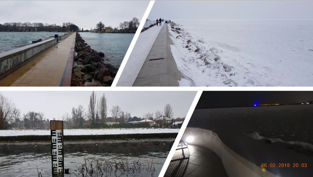
Based on the February 26, 2018 right bottom insert below, the blue laser is seen from some height ABOVE THE TOP of the levy walkway. That is not the 2.79 feet (1.6 meters) position that they advertised.
Also notice the thick layer of snow over the Lake.
Note also that FECORE never showed any cameras, people or detection devices sitting in the water (or snow) at the Siofok levy just 2.79 feet (1.6 meters) above the surface to intercept and record the blue laser beam image.
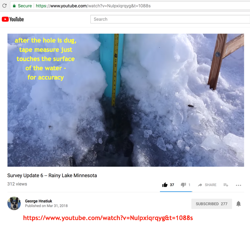
Based on their photo below, if they did venture out, the thickness of the ice adds to their height above the water line, further making their claim of 2.79 feet (1.6 meters) less correct.
They should have drilled a hole in the ice to measure its thickness and correctly locate the water line. They did not do that.
They simple made the 2.79 feet (1.6 meters) statement. That is not how evidence should be supplied for public corroboration and approval.
The February 26, 2018 right bottom insert IS NOT PROOF that the blue laser WAS SEEN AT 2.79 feet (1.6 meters) as they claimed.
-

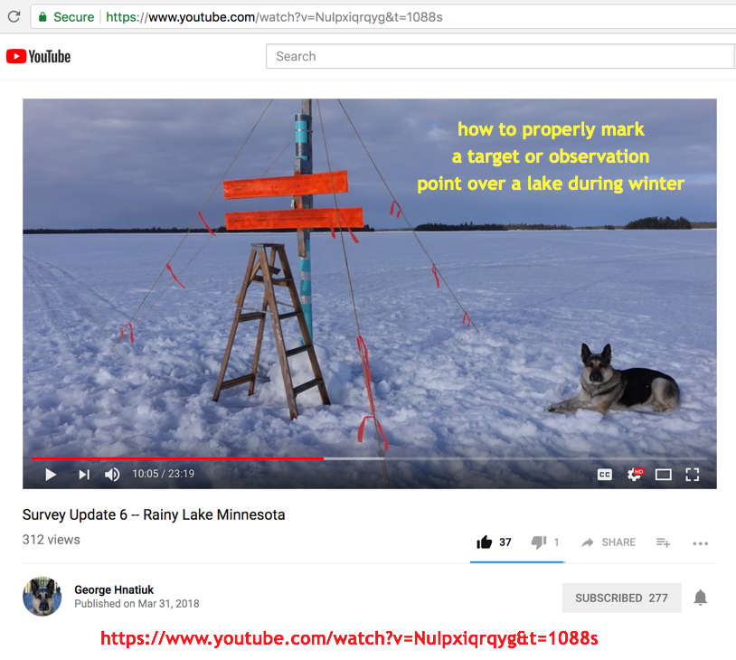
Here is an example by surveyor George Hnatiuk at Rainy Lake in Minnesota, on how to correctly determine a lake's water level during winter conditions.
FECORE did none of this...
-
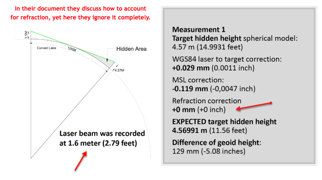
Understanding atmospheric refraction and how it influences measurements:
THE ACCURACY OF THE DETERMINATION OF TERRESTRIAL REFRACTION FROM RECIPROCAL ZENITH ANGLES, by K. Ramsayer of the Geodetic Institute of the University of Stuttgart.
https://www.cambridge.org/core/services/aop-cambridge-core/content/view/S0074180900066018
Monitoring of the refraction coefficient in the lower atmosphere using a controlled set-up of simultaneous reciprocal vertical angle measurements
http://ddfe.curtin.edu.au/models/ERTM2160/pdf/Hirt2010_JGR_D21102_refraction_av.pdf
PROPAGATION OF REFRACTION ERRORS IN TRIGONOMETRIC HEIGHT TRAVERSING AND GEODETIC LEVELLING
http://www2.unb.ca/gge/Pubs/TR132.pdf
NOAA Technical Report NOS 92 NGS 22 Results of Leveling Refraction Tests National Geodetic Survey
https://www.ngs.noaa.gov/PUBS_LIB/ResultsOfLevelingRefractionTests_by_NGS_TR_NOS92_NGS22.pdf
-
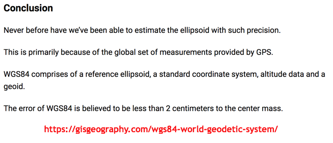
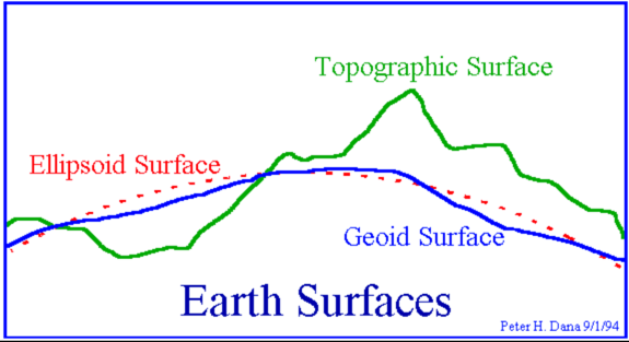
Notes on WGS 84...
-
Thanks for visiting.
- - - - - - - - - - - - - - - - - - - - - - - - - - - - - - - - - - - - - - - - - - - - - - - - - - - - - - - - - - - - - - - - - - - - - - - - - - - - -
Other articles here about the FECORE conspiracy flat Earth site:
FECORE - 2018 Lake Balaton; The Biggest Laser Experiment in History goes BUST
FECORE - February 1, 2018 update: Lake Balaton laser experiment now moving to plan B & C
FECORE - is based at North Liberty Mennonite Church
FE Astronomy - FE Core Project Foundation, Steve Torrence and Dr. Zack want more of your money
Steve Torrence - caught deleting video comments that expose flat Earth as a delusion
Karen B (Karen B. Endecott) - Big Foot is real and you can communicate with them telepathically
Bob Knodel - his Flat Earth conspiracy videos DEBUNKED
Published on – May 11, 2018
Discussion at - https://www.youtube.com/channel/UC7ipUKERU0tzYFxALJBli4A/discussion
Our home page all articles - http://flatearthlunacy.com
kind regards, JonahTheScientist