


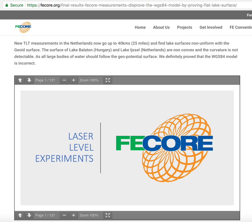
FECORE 2018 - Lake Balaton and Lake Ijssel laser test - PEER REVIEW
Dear Readers,
The following is our scientific analysis and discussion about the FECORE 2018 long distance laser experiments.
Please enjoy.
kind regards, JonahTheScientist
- - -
Update: August 2019:
The truth finally comes out of Mike Cavanaugh validating all we have said in this and our other articles on the FECORE laser test.
As Mike Cavanaugh finally explains in this August 2019 interview with Sly Sparkane, the goal of the laser test was to hit the distance target. Nothing else.
Our note: That does not prove the earth is flat. The laser can be aimed up/down and left/right. Point it above the horizon line any way you want just to get the laser light seen at the target location.
Aimed and traveling over the horizon the laser beam is refracted by the atmosphere and subject to other thermal distortions, before its ever widening beam (laser beam divergence) makes it to the distant target.
This only proved that the laser was bright enough to be seen from those distances. Nothing else.
Sly Sparkane says,
“What was the ultimate goal of the test? Was it to see the laser at the other end or was it to hit a target?”
Mike Cavanaugh says,
"to hit a target..."
Sly Sparkane says,
“and did you hit a target…”
Mike Cavanaugh says
“yes…”
Sly Sparkane says
“at 22 kilometers?”
Mike Cavanaugh says,
“at 20 and 26 or 27 or 29 now…”
This is FECore (MIRRORED), by Flat Earth Reset 3
https://www.youtube.com/watch?v=V67XR5Xkhd8
Update: October 2019:
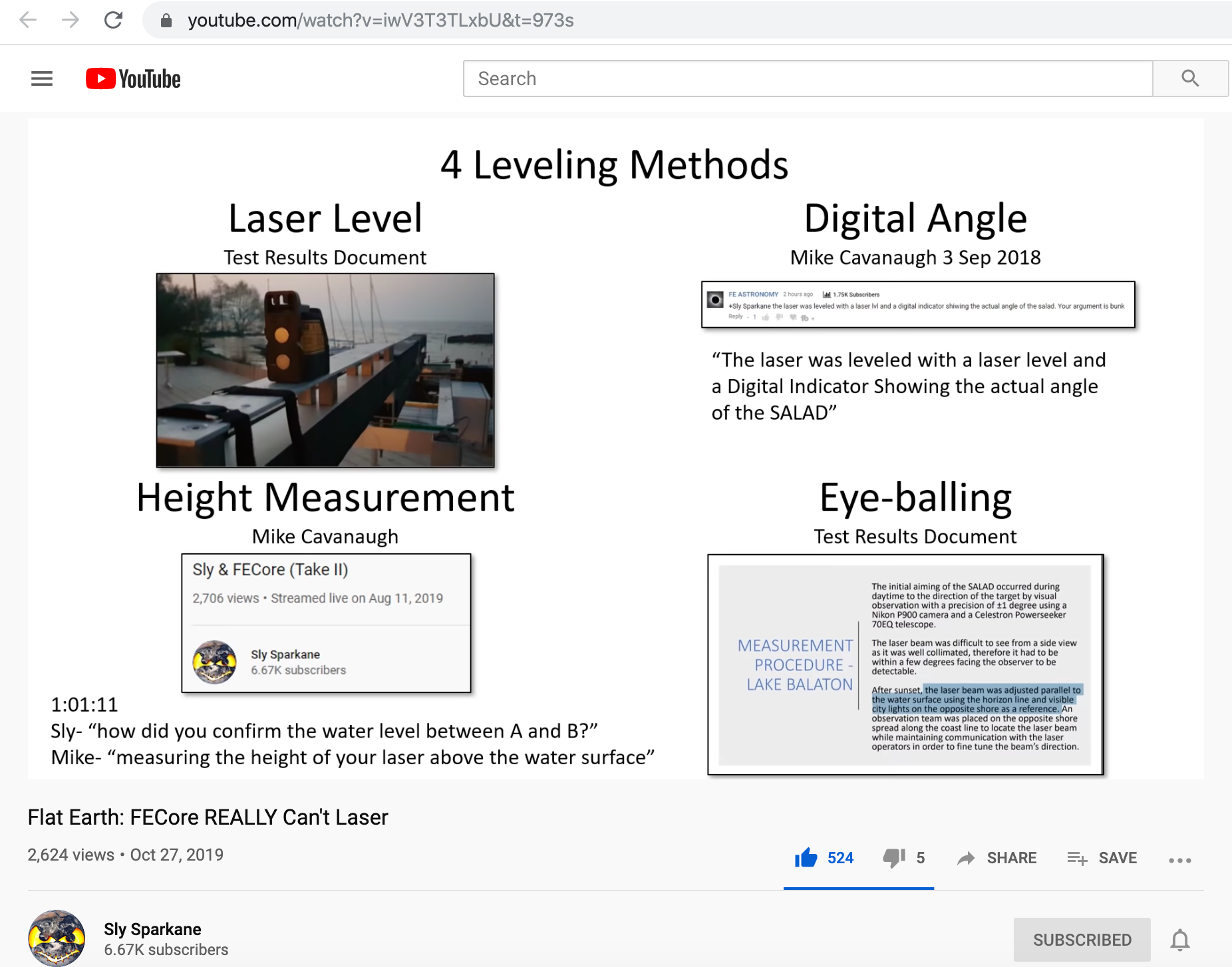
The following video by Sly Sparkane validates the main xx points that we presented 18-months ago.
Flat Earth: FECore REALLY Can'r Laser, by Sly Sparkane
https://www.youtube.com/watch?v=iwV3T3TLxbU&t=973s
-
-
-

- - - - - - - - - - - - - - - - - - - - - - - - - - - - - - - - - - - - - - - - - - - - - - - - - - - - - - - - - - - - - - - - - - - - - - - - - - - - - - - - - - - - - - -
Published on – June 14, 2018
The Peer Review Process:

Introduction:
Merits:
Critique:
Specific areas for improvement:
Manuscript recommendation: Withdraw
- - - - - - - - - - - - - - - - - - - - - - - - - - - - - - - - - - - - - - - - - - - - - - - - - - - - - - - - - - - - - - - - - - - - - - - - - - - - - - - - - - - - - - -
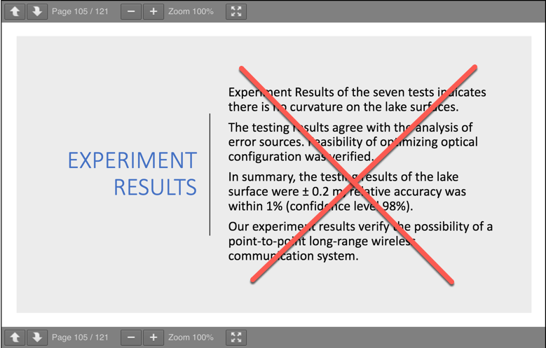
Abstract:
1. No attempt was ever made to measure Earth flatness.
During the entire course of the experiment they did not use any of the standard Geodetic survey tools; such as an internationally approved Theodolite/Auto level, GPS tracker, level staff, ranging rod, retro-reflector and surveyor’s tripod.
They did not place level staffs or sighting targets at various marker points along the Lake Balaton shoreline, to demonstration progressive tracking of Earth flatness over length.
They did not stake laser reflectors at various locations along the shoreline, and target them with a laser beam to demonstrate that the beam is truly pointed parallel to the water's surface over distance. That is a primary requirement to corroborate flatness.
2. All efforts were directed toward showing that there is no Earth curvature.
The FECORE team did however, attempt thru observations, to imply "proof by contradiction."
Proof by contradiction is a form of indirect proof, that establishes the truth or validity of a proposition. It starts by assuming that the opposite proposition is true, and then shows that such an assumption leads to a contradiction.
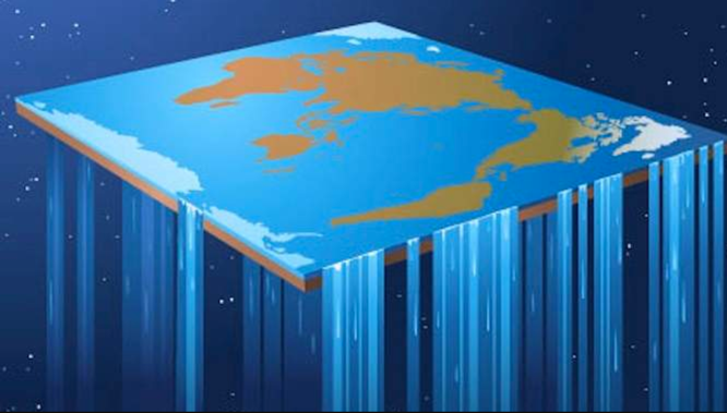
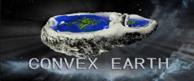
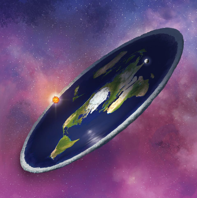
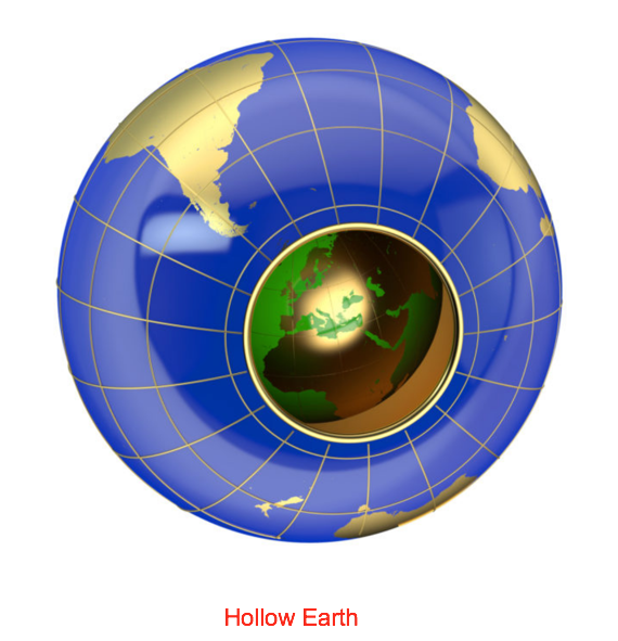
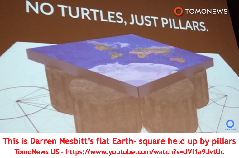
The error in this type of approach is the "assumption" that the Earth can only have two possible valid shapes - either flat or spherical. Attempting to prove that the Earth is not spherical, does not authenticate that the Earth is flat. And other flat Earth supporters willingly testify that the Earth is concave, convex, or undoubtedly a flat plane with as yet unmeasured total dimensions.
3. The laser used by FECORE was never demonstrated to run parallel to the water's surface, across the entire target span.
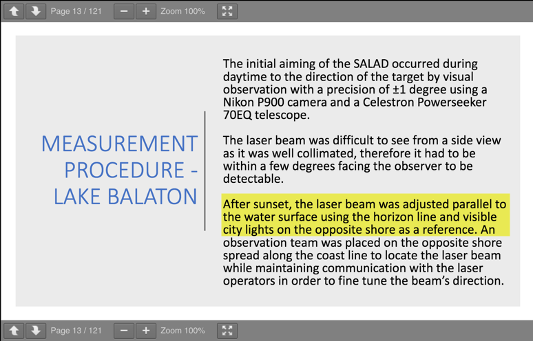
In slide 13 they state:
"the laser beam was adjusted parallel to the water surface using the horizontal line and visible city light on the opposite shore as reference."
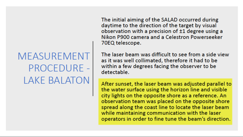
This alone invalidates all of FECORE's math and conclusions, because their laser beam was not parallel to the lakes water line.
Best laser test method for flatness is, the STEP method:
Shooting a beam across an area, and making consistent interval beam height measurements above the water line, across the entire area.
What FECORE did was:
"I see it so the water must be flat"
Just observing a laser source from a distance location does not indicate flatness or curvature.
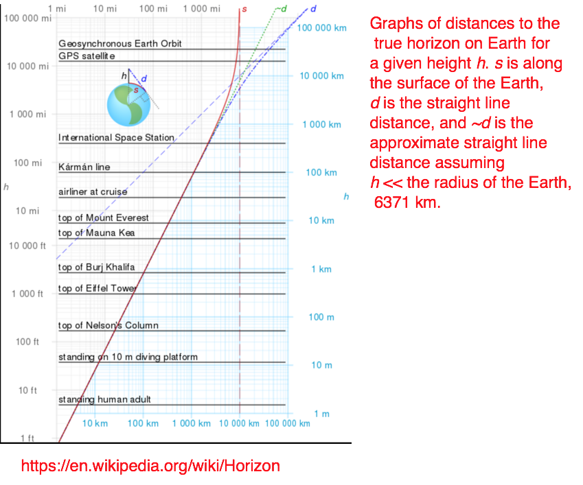
4. In order to avoid confusing and contestable results due to atmospheric effects - all laser experiments should only be conducted within the observable horizon.
Laser height above the water line:
1.5 meters = Test over water to a distance of (4.4 kilometers / 2.73 miles)
5 meters = Test over water to a distance of (8 kilometers / 4.97 miles)
10 meters = Test over water to a distance of (11.3 kilometers / 7 miles)
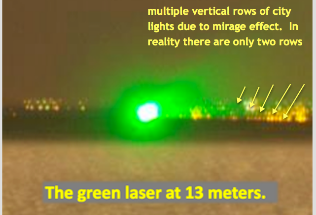
13 meters (hotel terrace position of laser) = Test over water to a distance of (12.9 kilometers / 8 miles)
20 meters = Test over water to a distance of (16 kilometers / 9.94 miles)
30 meters = Test over water to a distance of (19.6 kilometers / 12.18 miles)
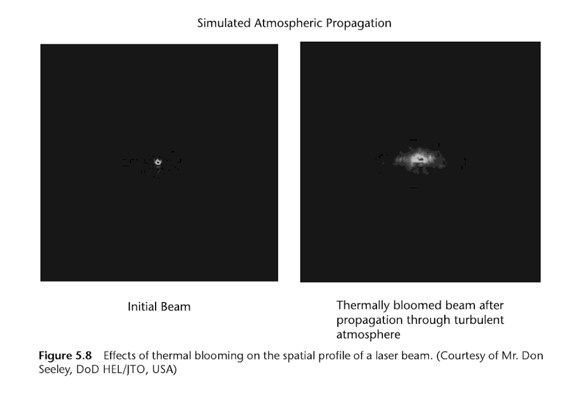
The below mentioned phenomena radically change light propagation direction and behavior:
turbulence (rising and falling air currents, and the offshore breeze that all sailors know about)
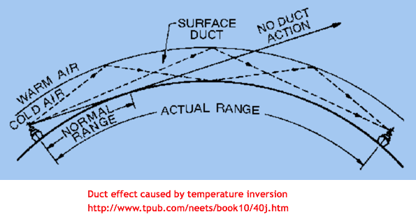
thermal layer ducting
thermal boundary layers
thermal blooming
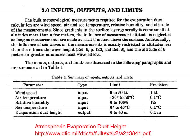
evaporation duct height
atmospheric looming, sinking, towering & stooping
inferior mirage, superior mirage, and Fata Morgana
5. The laser beam (green & blue) diameter is on the order of millimeters, yet the resulting observed light images observed at the target locations are meters upon meters wide.
6. Given the small beam at the source, diffraction and natural beam divergence produces a large (order of meter or meters) beam at the detector.
7. Regardless of atmospheric refraction/ducting, this large beam is essentially a plane wave, large enough to reach from near the ground to the location of the detector (eye or camera) at the various test distances on it's own.
-
Snell's law of refraction is not valid for atmospheric calculations
The determination of atmospheric refraction made by FECORE, has been proved to be wrong math by Walter Bislin.
8. Whether by eye or camera, a small portion of this plane wave is sampled and appears as a spot in the camera. This spot is sometimes distorted by small scale aberrations in the atmosphere or scatter of diffracted light off the surface of the water.
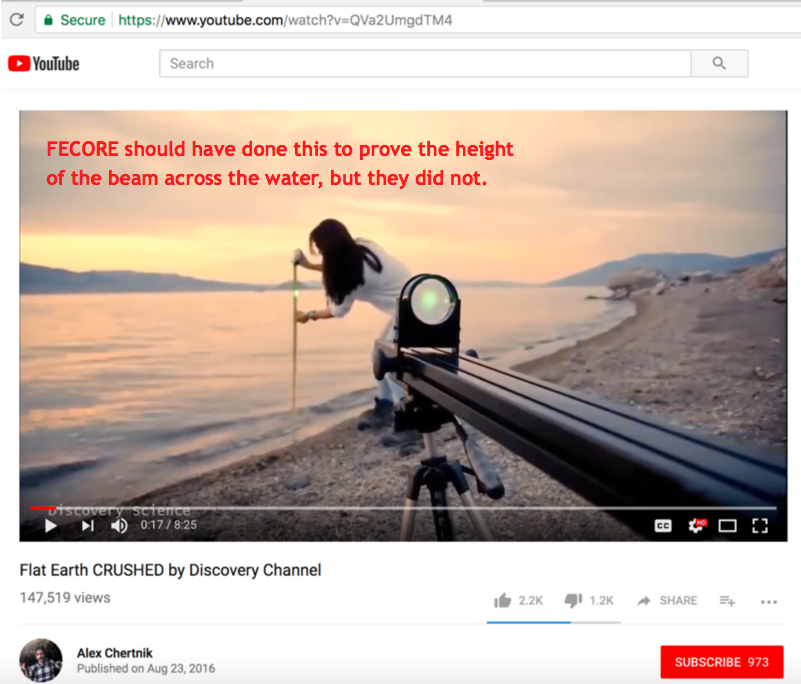
9. While they didn't show it or do it, they would have seen the same spot as they moved the detector up and down vertically (sampling different parts of the beam). Please note that to find the beams actual location would require finding the center of the beam (the brighter center). If they had done that, you could have drawn conclusions about the extent of refraction/ducting.
10. We will show below how to properly conduct an over-the-water laser distance experiment.
11. Lighthouse or bright lamp testing could also have been used to obtain reliable results.
12. Basically, this experiment (if they had scanned vertically at each target point) suggests that diffraction is real and doesn't show whether the earth surface curves or not.
Summary:
We have found FOUR primary reasons why every laser observation that FECORE conducted for this experiment was critically flawed - and therefore invalid.
1. Seeing the laser beam at each target point does not prove that the Earth is flat or curved. It only proves that the laser had enough power intensity (wattage) for the beam to reach the distance.
2. Every laser test past the primary horizon (2.85 meter laser height reaches the horizon at distance 6-km) has to contend with light bending, beam expansion and distortion from multiple effects, such as:
turbulence (rising and falling air currents, and the offshore breeze that all sailors know about)
thermal layer ducting
thermal boundary layers
thermal blooming
evaporation duct height
atmospheric looming, sinking, towering & stooping
inferior mirage, superior mirage, and Fata Morgana
.. and FECORE did not adjust their measurements for these.
3. The laser used by FECORE was never demonstrated to run parallel to the water, at any location along the test path. Therefore, all math computations and conclusions reached by FECORE in this experiment were based on wrong data.
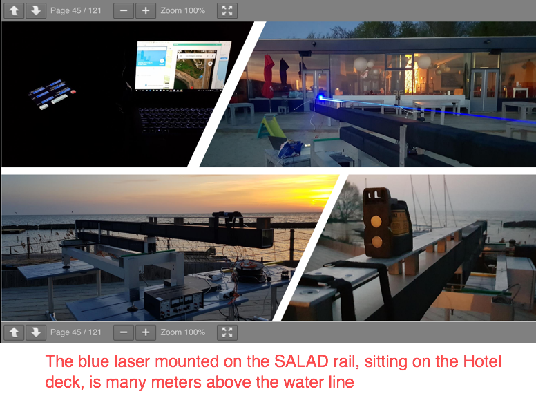
4. Claiming that the laser SALAD aiming device is 2.9 meters above the water line is one thing, but it does not end there.
Note: The SALAD device did not have GPS aiming enhancement at this time.
Sly & FECore (Take II) - https://www.youtube.com/watch?v=7dQjB1VQUG4
Their blunder was not showing/proving that the beam travelled horizontally PARALLEL to the water for each target test.
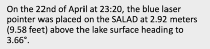
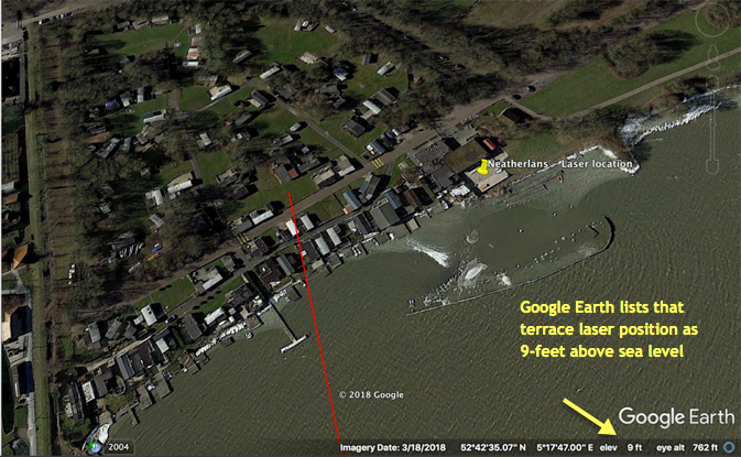
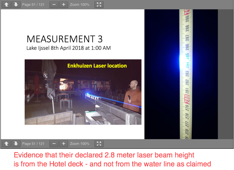
There is ALSO ample evidence that FECORE was not honest about the waterline height of their laser. For the Lake Ijssel experiments the test calculation slides list 2.92 meters as the laser height above the water, but in reality that 2.92 meters is the "elevation only" of the site where the laser SALAD apparatus was located. The true laser height above the water line is 2.92 meters, PLUS the hotel deck height above ground, PLUS the actual height of the SALAD apparatus sitting on the deck.
FECORE did not provide the angle (the exact degree above or below the horizontal) that the beam was pointing.
At what angle, by how many degrees & minutes & seconds they pointed the laser UP or DOWN in order for it to be seen at the target location - was not presented in their document. Knowing that angle is most important.
The laser can hit any over-the-horizon target, by just aiming it higher or lower enough, depending upon the atmospheric conditions.
As that is being done, the person at the target just has to say "I can see it now."
But by only doing that - the test is invalid.
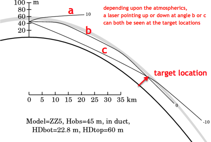
At no time was the laser beam leveled - shown or measured to run PARALLEL to the WATER. As such, all resulting beam observations are based on fictional (unknown) bean pointing.
5. FECORE did not show evidence at each target location that the laser beam was not visible by the horizon hidden amount.
- - - - - - - - - - - - - - - - - - - - - - - - - - - - - - - - - - - - - - - - - - - - - - - - - - - - - - - - - - - - - - - - - - - - - - - - - - - - - - - - - - - - - - -
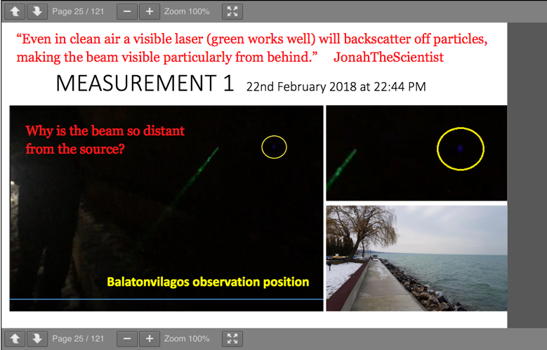
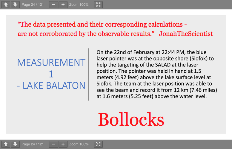
Measurement 1:
-
-
- - - - - - - - - - - - - - - - - - - - - - - - - - - - - - - - - - - - - - - - - - - - - - - - - - - - - - - - - - - - - - - - - - - - - - - - - - - - - - - - - - - - - - -
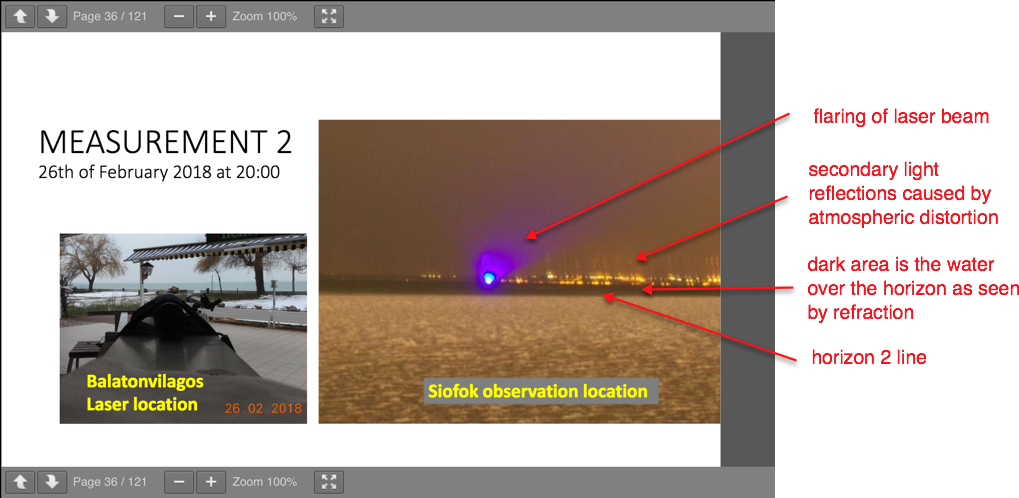
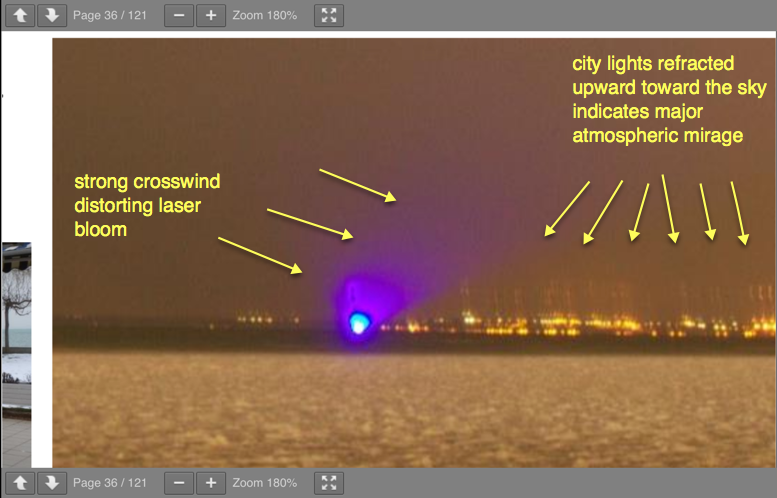
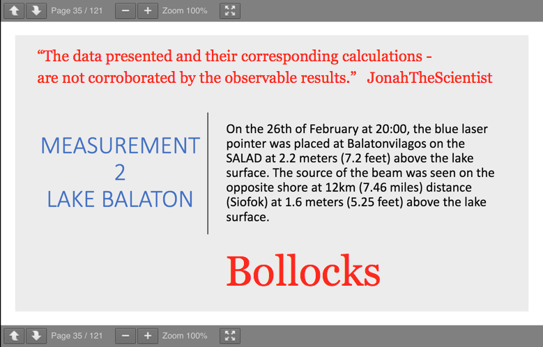
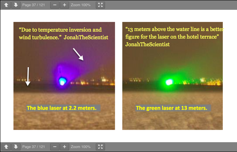
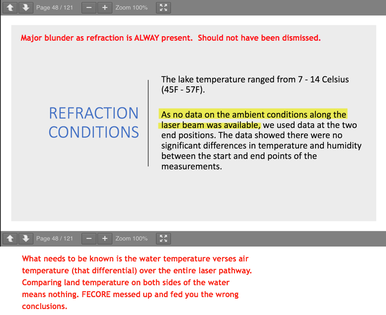
Measurement 2:
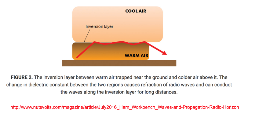
Due to a normal temperature gradient found in the atmosphere, light rays are bent 1/5 or 1/6 the Earth’s curvature.
With a temperature inversion (increase or decrease) of 6.3o F per 100-feet, the curvature of a light ray is of the same order as the curvature of the Earth.
-
-
-
-
-
- - - - - - - - - - - - - - - - - - - - - - - - - - - - - - - - - - - - - - - - - - - - - - - - - - - - - - - - - - - - - - - - - - - - - - - - - - - - - - - - - - - - - - -
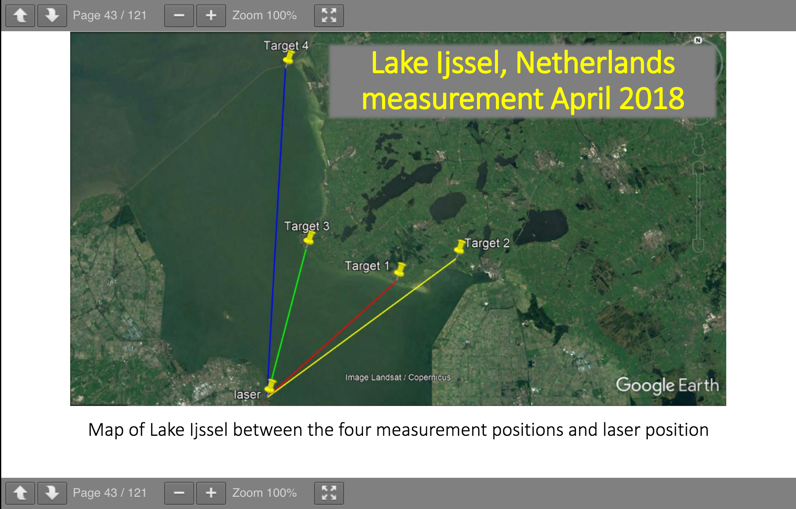
FECORE - Lake Ijssel Neterlands laser pictures presented...
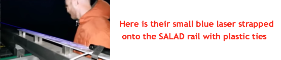
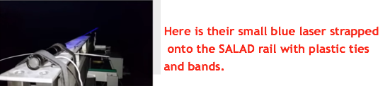
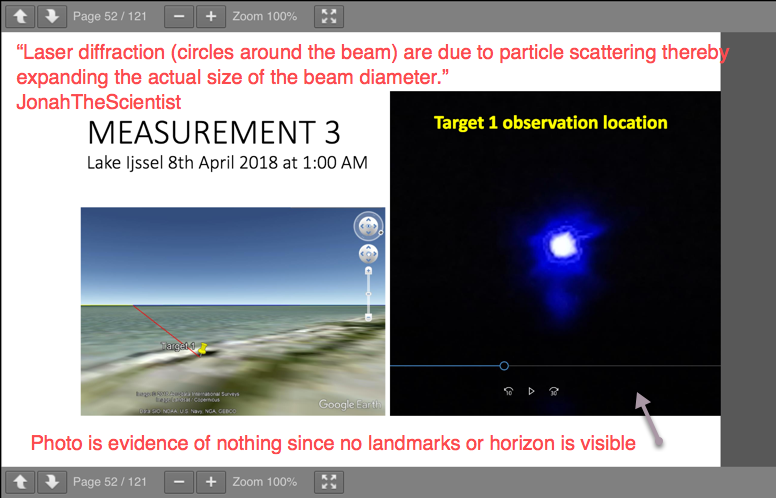
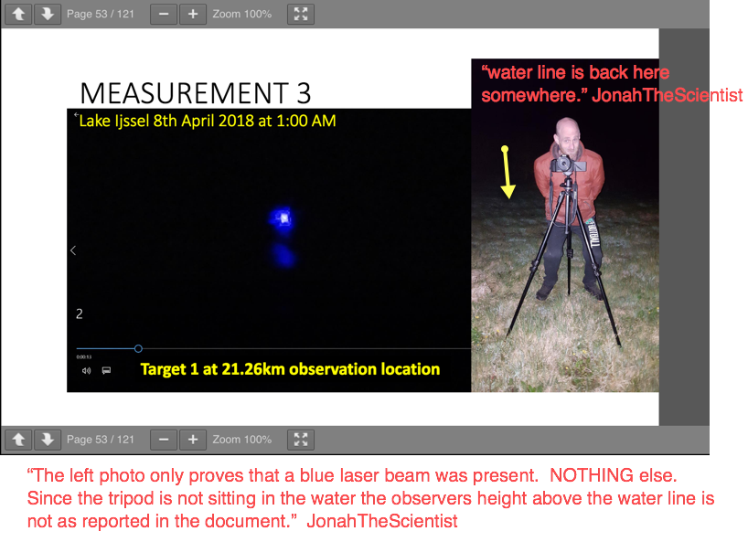
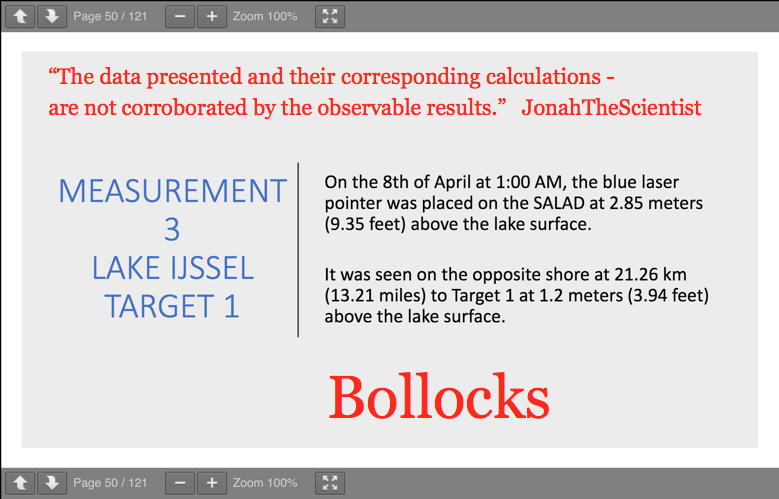
Measurement 3:
-
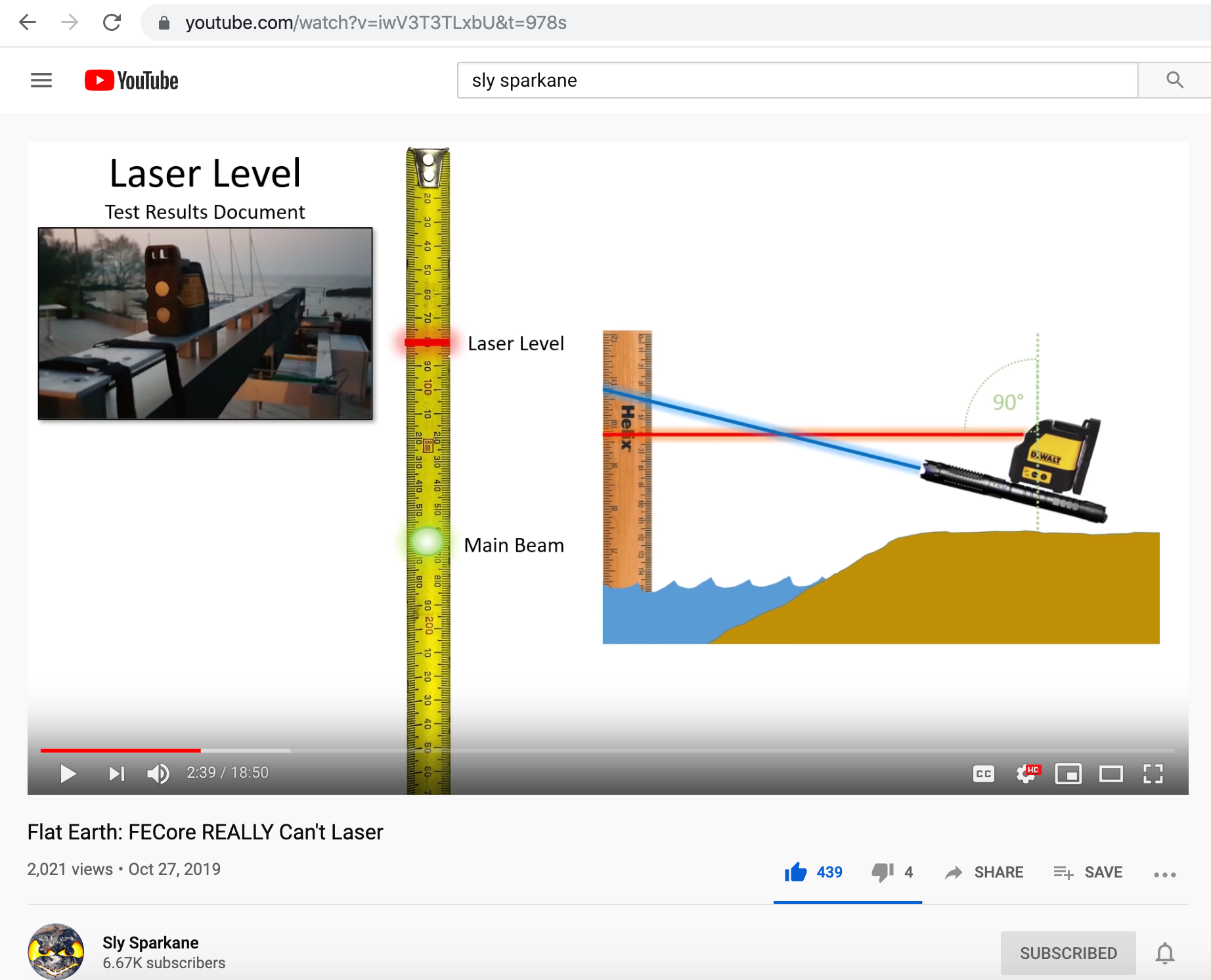
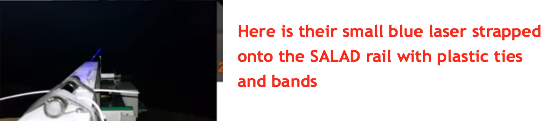
Bottom right photo shows the Dewalt DW088 Cross Line Laser. It sends out a laser cross beam for self leveling, used in construction.
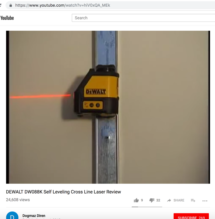
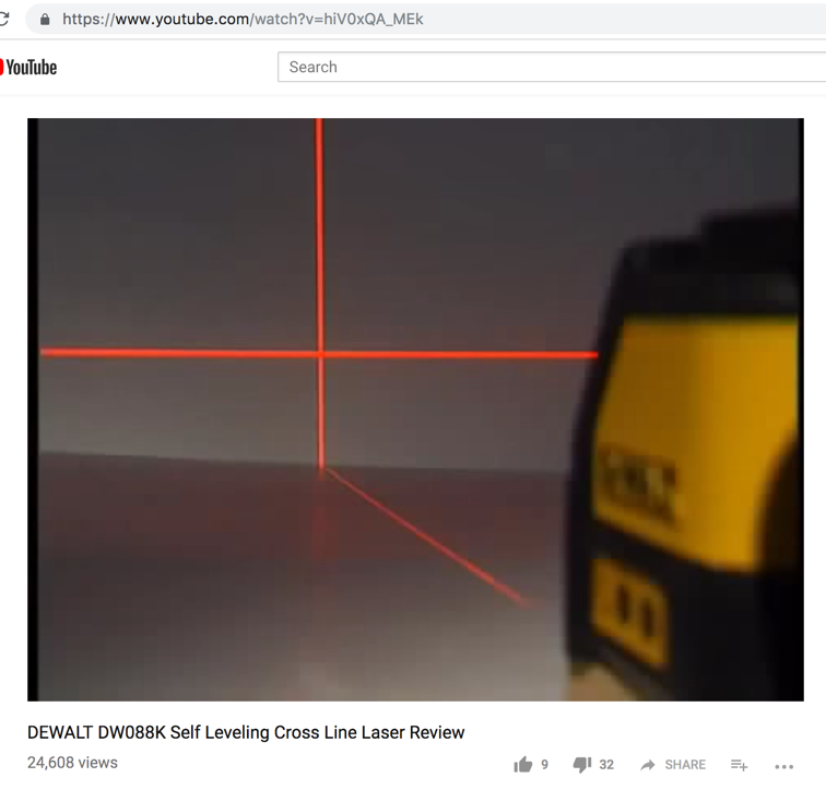

As stated here below, "it uses an internal pendulum to ascertain true plumb and level lines..." So it projects a laser level line parallel to the Earth's surface based on the center of gravity. And that is good and fine by itself.
HOWEVER, for this experiment the laser needs to be shown as running parallel to the waters surface for the entire distance. The DeWalt sitting on top of the laser appratus does not do that.
Main aiming error here = since the Earth has curvature aiming the laser at the horizon means IT IS NEVER parallel to the actual water surface, every foot of the way.
This is how a laser needs to be verified as parallel to the water line for the entire length of the run. FECORE did not do this...
- - -
-
-
-
-
-
- - - - - - - - - - - - - - - - - - - - - - - - - - - - - - - - - - - - - - - - - - - - - - - - - - - - - - - - - - - - - - - - - - - - - - - - - - - - - - - - - - - - - - -
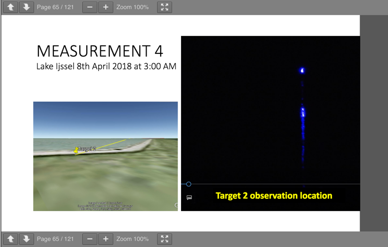
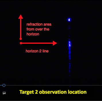
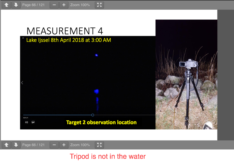
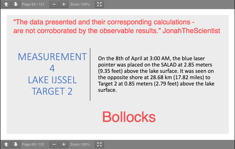
Measurement 4:
-
-
Diffused light due to waves causes a reflected skipping effect...
Light skipping across water wave...
-
-
- - - - - - - - - - - - - - - - - - - - - - - - - - - - - - - - - - - - - - - - - - - - - - - - - - - - - - - - - - - - - - - - - - - - - - - - - - - - - - - - - - - - - - -
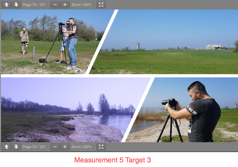
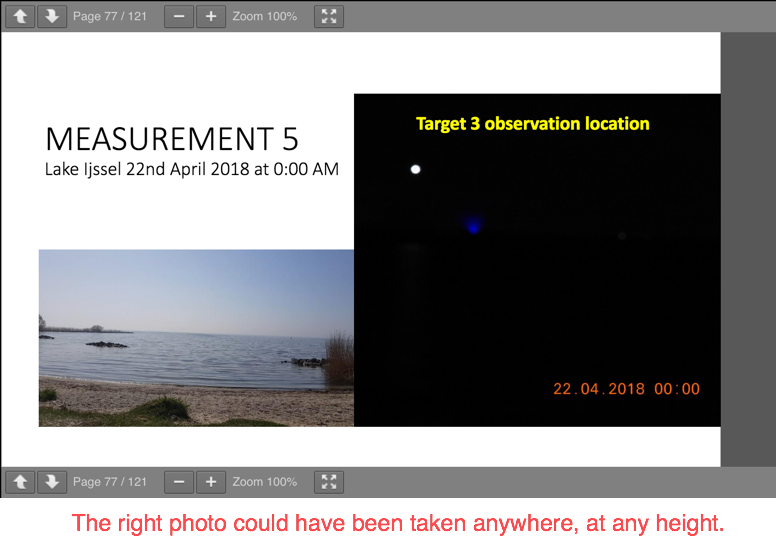
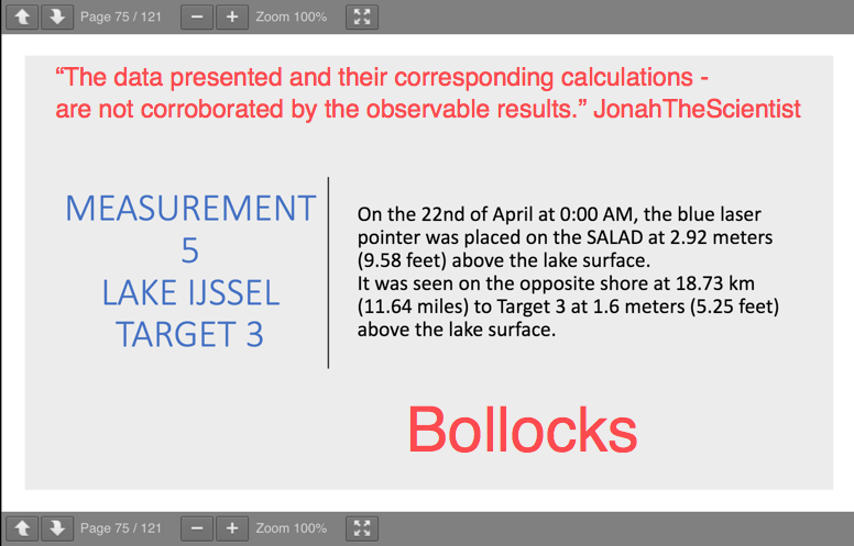
Measurement 5:
-
-
- - - - - - - - - - - - - - - - - - - - - - - - - - - - - - - - - - - - - - - - - - - - - - - - - - - - - - - - - - - - - - - - - - - - - - - - - - - - - - - - - - - - - - -
Measurement 6:
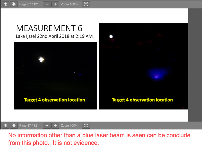
-
- - - - - - - - - - - - - - - - - - - - - - - - - - - - - - - - - - - - - - - - - - - - - - - - - - - - - - - - - - - - - - - - - - - - - - - - - - - - - - - - - - - - - - -
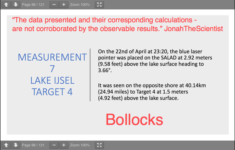
Measurement 7:
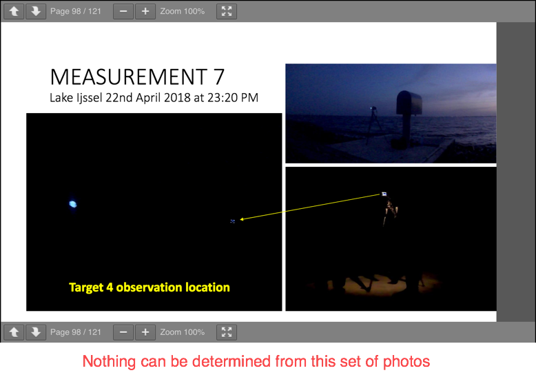
-
- - - - - - - - - - - - - - - - - - - - - - - - - - - - - - - - - - - - - - - - - - - - - - - - - - - - - - - - - - - - - - - - - - - - - - - - - - - - - - - - - - - - - - -
FECORE conclusion:
- - - - - - - - - - - - - - - - - - - - - - - - - - - - - - - - - - - - - - - - - - - - - - - - - - - - - - - - - - - - - - - - - - - - - - - - - - - - - - - - - - - - - - -
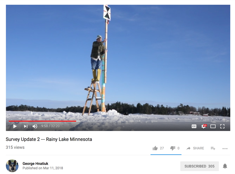
1. No attempt was ever made to measure Earth flatness.
More explanation:
None of these standard surveying measuring tools were ever used by FECORE in their experiments. If they had, earth curvature would have been proven right off the bat.
Setup standard height markers at various distances, in ice or on land...
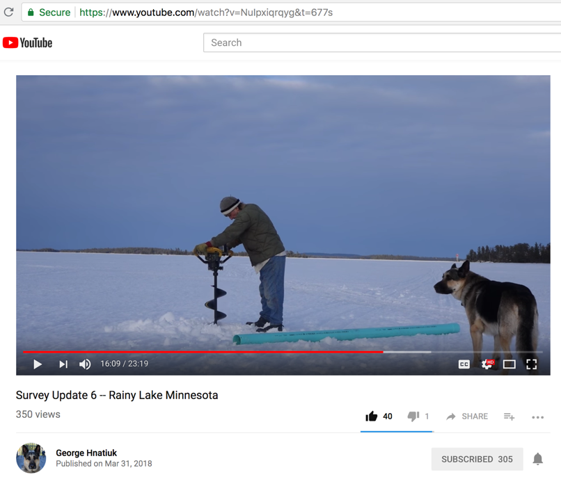
Video here - https://www.youtube.com/watch?v=NuIpxiqrqyg&t=677s
-
-
View all markers with the auto level to determine elevation and curvature over distance. It's best to place all markers within the same line of sight. No more than 1,500 yards' maximum separation distance between markers is needed, so that atmospheric inversion and refraction do not play any role in the measurement.
Easy done deal with no room for debate!
- - - - - - - - - - - - - - - - - - - - - - - - - - - - - - - - - - - - - - - - - - - - - - - - - - - - - - - - - - - - - - - - - - - - - - - - - - - - - - - - - - - - - - -
2. All of their efforts were directed toward showing that there is no Earth curvature.
More explanation:
Trying to prove that the Earth has no curvature does not prove that the Earth is flat. That's because various peoples and cultures of the world attest that the Earth really is ...
-
-
-
-
-
-
-
-
-
-
etc.
- - - - - - - - - - - - - - - - - - - - - - - - - - - - - - - - - - - - - - - - - - - - - - - - - - - - - - - - - - - - - - - - - - - - - - - - - - - - - - - - - - - - - - -
3. FECORE did not perform this step test, or any test to prove that their laser was parallel to the water line, the entire length of the experiment.
Just saying or showing "I can see the laser" from some distant shore is a fouls errand, and proves nothing.
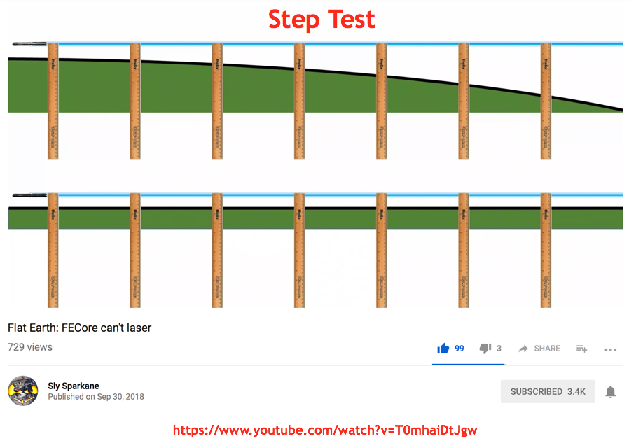
This is how a laser needs to be verified as parallel to the water line for the entire length of the run. FECORE did not do this...
- - - - - - - - - - - - - - - - - - - - - - - - - - - - - - - - - - - - - - - - - - - - - - - - - - - - - - - - - - - - - - - - - - - - - - - - - - - - - - - - - - - - - - -
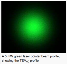
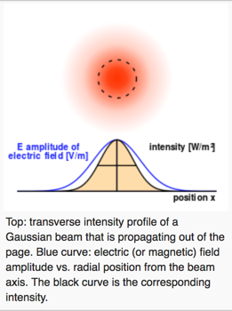
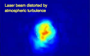
4. In order to avoid confusing and contestable results due to atmospheric effects - all laser experiments should only be conducted within the observable horizon.
More explanation:
Here is what a laser beam looks like (normal Gaussian distribution) when there is no interference for external effects. It's obvious that NONE of the laser images at the target site shown by FECORE look like this.
-
-
-
-
-
-
-
-
- - - - - - - - - - - - - - - - - - - - - - - - - - - - - - - - - - - - - - - - - - - - - - - - - - - - - - - - - - - - - - - - - - - - - - - - - - - - - - - - - - - - - - -
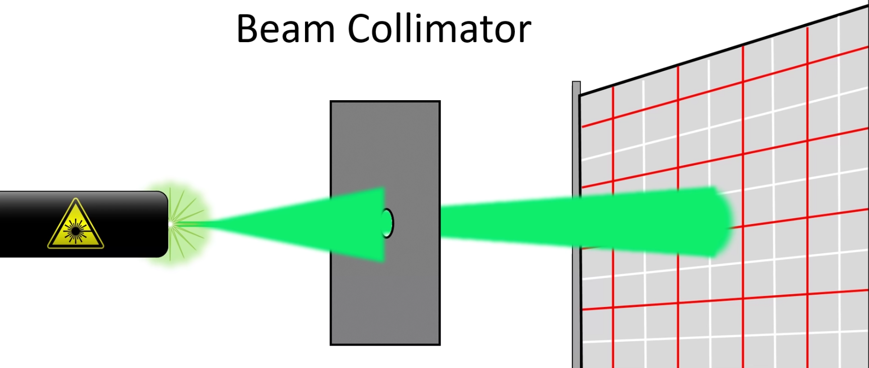
5. The laser beam (green & blue) diameter is on the order of millimeters, yet the resulting observed light images observed at the target locations are meters upon meters wide.
More explanation:
Limitations for the Focusing of Laser Beams (assuming no atmospheric or other type of distortion)
Laser beams can be used for transmitting optical energy to rather small spots or with low beam divergence over large distances. However, there are limitations to this, which involve the optical wavelength, the beam quality and the transverse size of the used focusing or collimation optics.
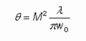
If a laser beam is focused to a spot beam waist with beam redius w0, it exhibits a certain beam divergence angle which is inversely proportional to the waist beam radius and proportional to the optical wavelength in the M2 factor:
The used focusing optics must be able to handle that amount of beam divergence; a limitation for that results from the limited numerical aperture of the optics. Also, if the focus has to have a large distance from the focusing optics and/or the waist beam radius is small or the beam quality is low, the beam radius in the focusing optics will necessarily be quite large. A correspondingly large open aperture of the optics is required. Such factors can in practice set a lower limit to the achievable beam radius in the focus, or an upper limit to the tolerable M2 factor of the beam:
- - - - - - - - - - - - - - - - - - - - - - - - - - - - - - - - - - - - - - - - - - - - - - - - - - - - - - - - - - - - - - - - - - - - - - - - - - - - - - - - - - - - - - -
6. Given the small beam at the source, diffraction and natural beam divergence produces a large (order of meter or meters) beam at the detector.
More explanation:
- - - - - - - - - - - - - - - - - - - - - - - - - - - - - - - - - - - - - - - - - - - - - - - - - - - - - - - - - - - - - - - - - - - - - - - - - - - - - - - - - - - - - - -
7. Regardless of atmospheric refraction/ducting, this large beam is essentially a plane wave, large enough to reach from near the ground to the location of the detector (eye or camera) at the various test distances on it's own.
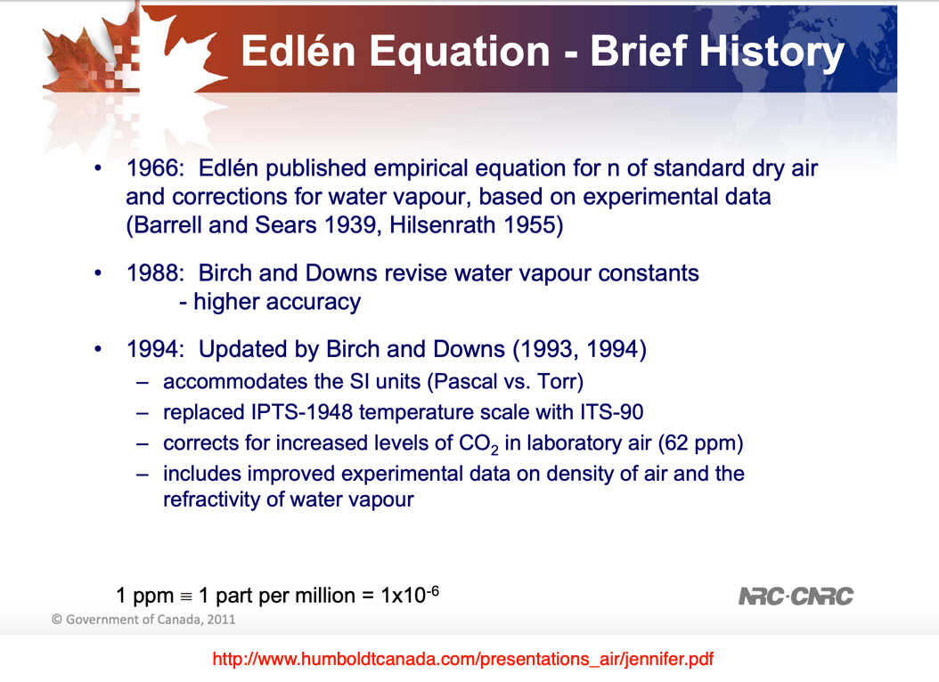
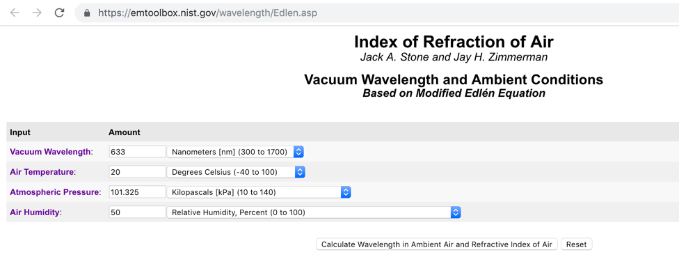
Concerning the modified Edlen Equation. They talk about it but we are unsure if they actually used it.
https://emtoolbox.nist.gov/wavelength/Edlen.asp
Using Snell's law is invalid for atmospheric refraction calculations. Snell's law calculates refraction when a distinct boundary in isotropic media ie encountered, like from air to water. But our atmosphere changes density/temperature very gradually with increasing elevation above the surface. So instead, our atmosphere is an anisotropic media.
More explanation:
Walter Bislins
http://walter.bislins.ch/
Advanced Earth Curvature Calculator
http://walter.bislins.ch/bloge/index.asp?page=Advanced+Earth+Curvature+Calculator
Creating an Equinox Sundial made of Paper
We can observe that at the Equinox the sun raises everywhere on earth exactly due east and sets everywhere exactly due west.
http://walter.bislins.ch/bloge/index.asp?page=Creating+an+Equinox+Sundial+made+of+Paper
- - -
Commentary from Walter Bislins...
Even using Snell's law (which they should not be using for atmospheric refraction) they still got the calcs wrong.
FECore's official conclusion from their LASER experiments "the earth is flat and the WGS84 model is wrong" is based on errors in the calculations, using Snell's law wrong, assuming a flat earth and a wrong physical model of the atmosphere.
They do not explain how they did their refraction calculations. The correct refraction calculation is the most essential part of the experiment. I have found out, how they did their refraction calculation.
They made fatal errors in every possible aspect. Let me explain:
4 fatal Errors in FECores laser experiments
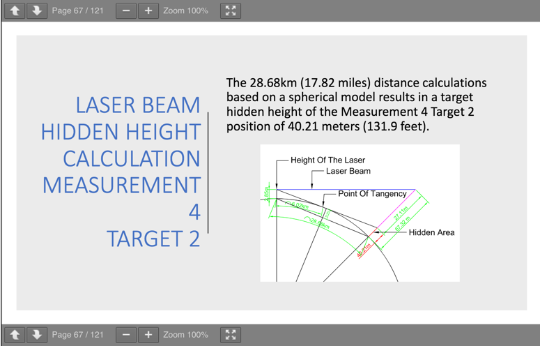
Note: I will use the values of the 4th measurement on the lake Ijssel as an example, but ALL their refraction calculations are wrong in the same way!
Distance = 28.68 km
Laser height = 2.85 m
Laser visible height at target = 0.85 m
Temperature at 2.85 m height = 11.8°C
Temperature at 0.85 m height = 7.6°C
Refraction index n1 at 11.8°C = 1.000283508 (source?)
Refraction index n2 at 7.6°C = 1.000287811 (source?)
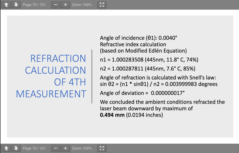
Published Refraction calculation
Angle of incidence (thera1): 0.0040°
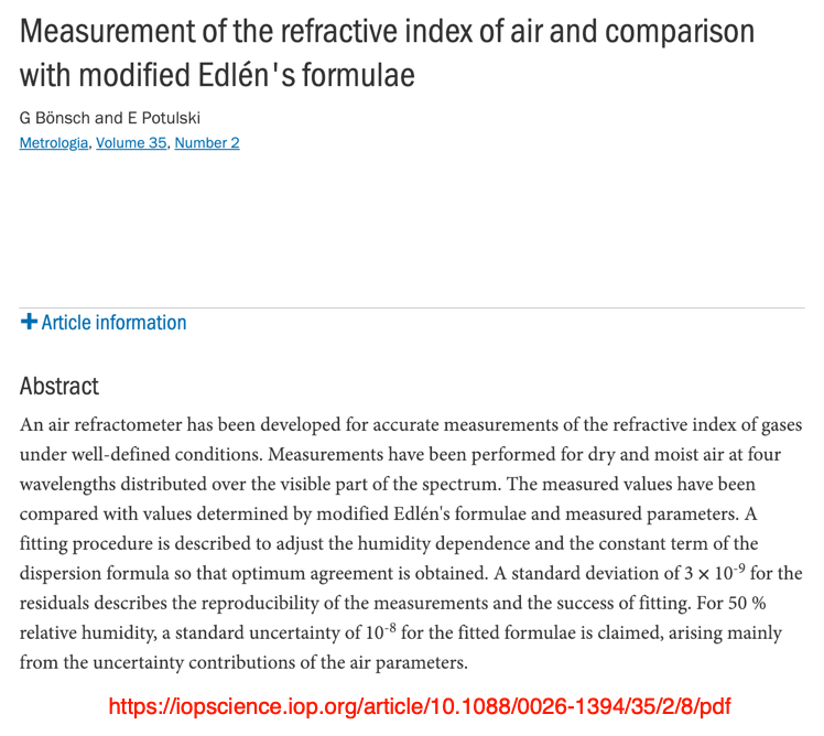
Refractive index calculation (based on Edlén Equation)
n1 = 1.000283508 (445nm, 11.8°C, 74%)
n2 = 1.000287811 (445nm, 7.6°C, 85%)
Angle of refraction is calculated with Snell's law:
sin theta2 = (n1 * sin theta1)/n2 = 0.003999983 degrees
Angle of deviation = 0.000000017°
We concluded the ambient conditions refracted the laser beam downward by maximum of 0.494 mm (0.0194 inches)
How FECore calculated refraction
Here is what I have found out about the refraction calculation of FECore:
I don't know how they measured the "angle of incidence" of 0.0040°. But anyway, lets calculate:
They used the Edlén Equation to calculate the refraction index for a certain wavelength, temperature and humidity. I did not check this calculation, but it seems reasonable.
They used Snell's law to calculate the "Angle of refraction" theta2 (trig functions in deg mode):
theta2 = arcsin( (n1 * sin(theta1)) / n2 ) = 0.003999983°
Their "Angle of deviation" is simply the difference theta2 - theta1 = 0.00000001721°
The maximum refraction correction (d) at the target is calculated by (trig function wrongly in rad mode!):
d = 28680 m * tan( 0.000000017 ) = 0.493 mm
Error 1: stupid Refraction Model
FECore assumed a flat earth and that the air consists of 2 flat layers with constant refractive indices. The lower layer with refractive index n2 is assumed to go from ground level to 2.85 m, which is just below the height of the laser. Above that, where the laser is placed, they assumed a layer with refractive index n1. In the "Refraction Theory" of FECore, the laser enters with an angle of 0.004° measured from the n1 layer at the position of the laser the n2 layer.
This is a complete wrong model for the atmosphere. Refraction in the atmosphere is gradual, even if the earth is flat. It depends mainly on the temperature Gradient (change of the temperature with height), which results in a corresponding density Gradient. If you have a density gradient, you cannot apply Snell's law like FECore did.
Error 2: using Snell's law with the wrong angle of incidence
Snell's law: sin( theta2 ) / sin( theta1 ) = n1 / n2
Where theta1 is the angle of incidence (angle of the ray measured against the perpendicular to the boundary layer) in the medium with refractive index n1 and theta2 is the angle of incidence in the medium with refractive index n2.
FECore used not the angle of incidence measured from the perpendicular to the boundary layer, but the angle measured up from the boundary layer. So they should have used theta1 = 90°-0.0040°.
Error 3: wrong refraction angle used
If the 2-layer model for atmospheric refraction were correct and if they would calculate the correct refraction angle using the right angle of incidence, then they should use this refraction angle to calculate their refraction correction. But FECore took the difference between the angle of incidence and the angle of refraction as their refraction angle, which is conveniently about 230,000 times smaller than the refraction angle from Snell's law.
Error 4: wrong calculation of refraction correction
The refraction correction is simply the deviation of the laser at the target due to refraction compared with the unrefracted beam. FECore computed the refraction correction simply using the following equation, which I have reconstructed from the published values (theta2 = 0.00000001721°). This formula would be correct if the stupid refraction model would be correct:
correction = distance * tan( theta2 )
Here they messed up with the tan function. They used theta2 given in degrees but used the tan function in radian or they interpreted theta2 as radian and converted to degrees and then applied the tan function in trig mode deg:
correction = dist * tan( theta2 * 180 / pi ) = 28680 m * tan( 0.00000001721 * 180 / pi ) = 0.494 mm
Error 5: thinking the earth is flat.
Error 6: sin theta2 = (n1 * sin theta1)/n2 = 0.003999983 degrees
is not a valid equation. sin( theta2 ) can not be equal 0.003999983 degrees.
Correct would be: theta2 = arcsin( n1 * sin(theta1) / n2 ) = 0.003999983°
But it does not matter, they used the wrong model and the wrong angle theta1 anyway.
- - - - - - - - - - - - - - - - - - - - - - - - - - - - - - - - - - - - - - - - - - - - - - - - - - - - - - - - - - - - - - - - - - - - - - - - - - - - - - - - - - - - - - -
8. Whether by eye or camera, a small portion of this plane wave is sampled and appears as a spot in the camera. This spot is sometimes distorted by small scale aberrations in the atmosphere or scatter of diffracted light off the surface of the water.
More explanation:
- - - - - - - - - - - - - - - - - - - - - - - - - - - - - - - - - - - - - - - - - - - - - - - - - - - - - - - - - - - - - - - - - - - - - - - - - - - - - - - - - - - - - - -
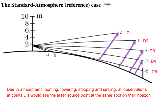
9. While they didn't show it or do it, they would have seen the same spot as they moved the detector up and down vertically (sampling different parts of the beam). Please note that to find the beams actual location would require finding the center of the beam (the brighter center). If they had done that, you could have drawn conclusions about the extent of refraction/ducting).
More explanation
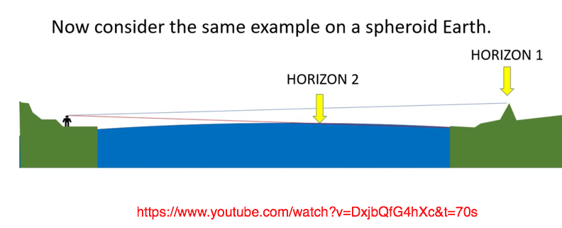
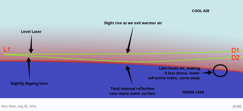
A camera at position D1 or D2, which are clearly at different heights above the surface, will still see the laser source at the SAME place L1 on their horizon.
-
- - - - - - - - - - - - - - - - - - - - - - - - - - - - - - - - - - - - - - - - - - - - - - - - - - - - - - - - - - - - - - - - - - - - - - - - - - - - - - - - - - - - - -
10. We will show below how to properly conduct an over-the-water laser distance experiment.
More explanation:
- - - - - - - - - - - - - - - - - - - - - - - - - - - - - - - - - - - - - - - - - - - - - - - - - - - - - - - - - - - - - - - - - - - - - - - - - - - - - - - - - - - - - - -
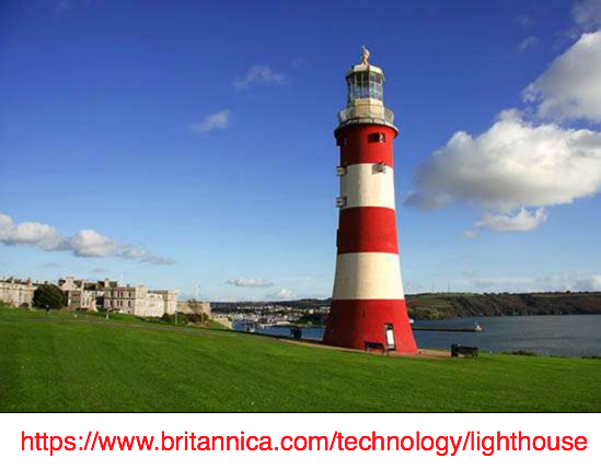
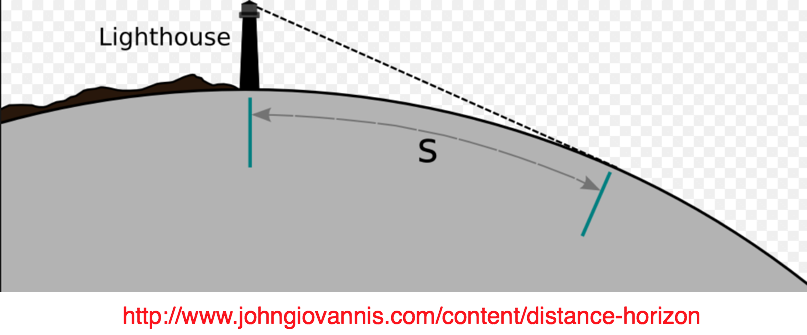
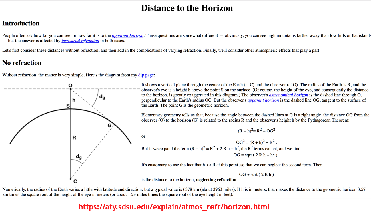
11. Lighthouse or bright lamp testing could also have been used to obtain reliable results.
More explanation:
-
-
- - - - - - - - - - - - - - - - - - - - - - -
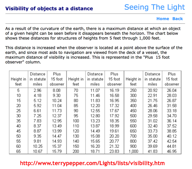
How to test using a hand held commercial lantern on a pole.
The following $60 lantern can be seen out to a distance (with the naked eye alone) of 10-miles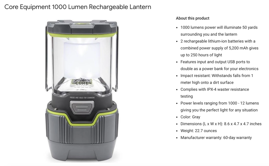
Inverse Square Law for lantern/lightbulb
B = L/4πd2
For L, luminosity, we use lumens.
For B, brightness, we use lumens/m2 or lux.
For d, we use miles
Example:
If d is tripled, then B decreases by a factor of 1 divided by 32 or 1/9 the brightness.
The full moon on a clear night is about 0.3-lux in brightness
Moonless clear night sky is about 0.002-lux in brightness
The unaided human eye can detect brightness down to about 0.001-lux
For that lantern, 10-miles should not be an issue.
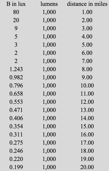
Curved Earth test...
So put that lantern on a pole, get on a small boat, and travel away. Record at what distance (lantern to boat) the lantern light can first be observe.
If the lantern is on a 10-foot pole, and you are standing 6-feet above the water line on your boat, as you approach the shore you should begin to see the lantern about 7-miles away.
Flat Earth test - using the above (10-foot pole and 6-feet on the boat above the water line) you should have no trouble seeing the lanturn from 16-miles away, as the brightness is 0.3-lux, the same as a full moon.
So try it at 16-miles and show us your results (be sure to document positions using GPS).
OK FECORE?
- - - - - - - - - - - - - - - - - - - - - - -
-
-
- - - - - - - - - - - - - - - - - - - - - - - - - - - - - - - - - - - - - - - - - - - - - - - - - - - - - - - - - - - - - - - - - - - - - - - - - - - - - - - - - - - - - - -
SUMMARY:
- - - - - - - - - - - - - - - - - - - - - - - - - - - - - - - - - - - - - - - - - - - - - - - - - - - - - - - - - - - - - - - - - - - - - - - - - - - - - - - - - - - - - - -
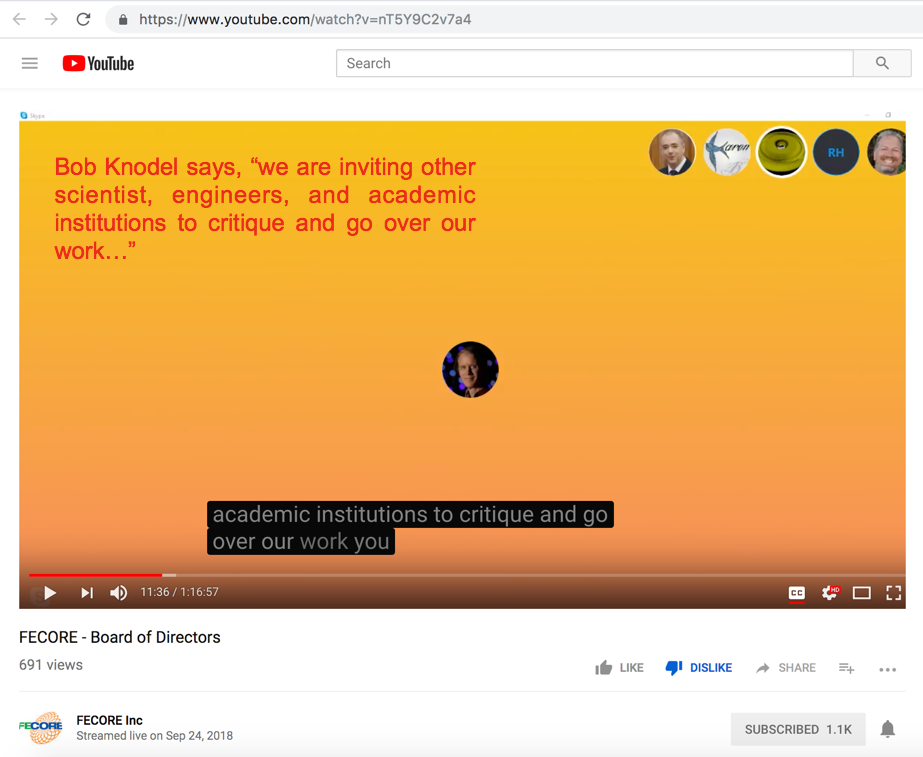
Invitation to Peer review:
-
-
- - - - - - - - - - - - - - - - - - - - - - - - - - - - - - - - - - - - - - - - - - - - - - - - - - - - - - - - - - - - - - - - - - - - - - - - - - - - - - - - - - - - - -

Despite the claim below, FECORE has not yet reposnded to our PEER review...
- - - - - - - - - - - - - - - - - - - - - - - - - - - - - - - - - - - - - - - - - - - - - - - - - - - - - - - - - - - - - - - - - - - - - - - - - - - - - - - - - - - - - - -
Update: September 28, 2018 - 2nd Invitation to Peer review
When we reminded FECORE of their neglect for not responding, they treated us with ridicule and mockery...
This is what they said...
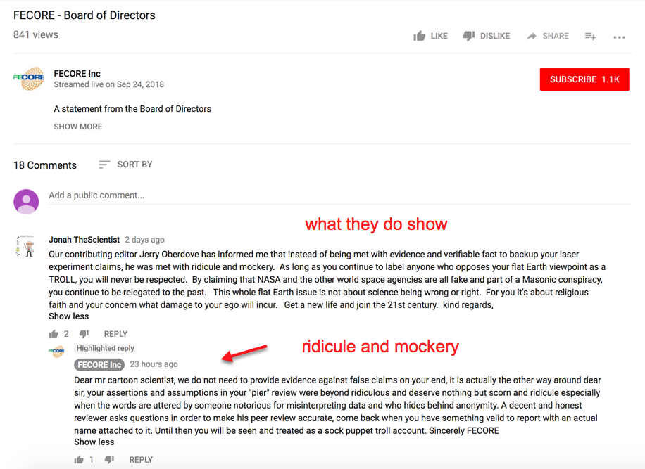
- - -
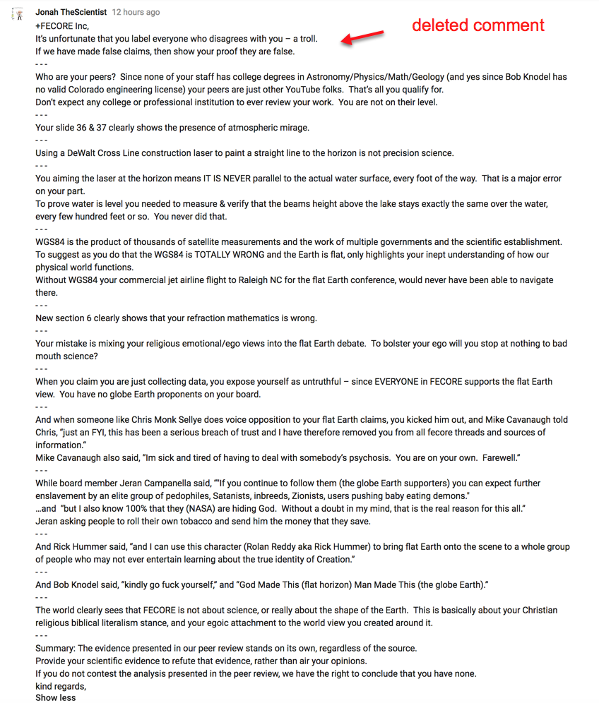
Our further response that they deleted from *PUBLIC view...

- - - - - - - - - - - - - - - - - - - - - - - - - - - - - - - - - - - - - - - - - - - - - - - - - - - - - - - - - - - - - - - - - - - - - - - - - - - - - - - - - - - - - -
Published on – June 14, 2018
Discussion at - https://www.youtube.com/channel/UC7ipUKERU0tzYFxALJBli4A/discussion
Our home page all articles - http://flatearthlunacy.com
kind regards, JonahTheScientist