


markksargent - USDA Surveyor talks about the Flat Earth - SW50 - Mark Sargent
Dear markksargent,
Fact check = You FAIL
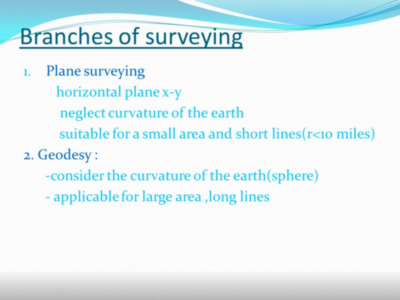
The surveyor must be familiar with mathematics, especially the application of trigonometry. Most traditional surveying is which does not take into account the curvature of the earth. For most surveying projects, the curvature of the earth is slight enough that the effects can be ignored, greatly simplifying the calculations involved.
For projects involving greater distances, the curvature of the earth must be taken into account; this is geodetic surveying, an application of geodesy.
Fact:
- contrary to what your guest says...
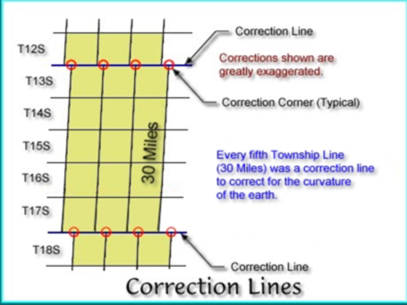
Platting, lot surveys, etc. are done with horizontal measurements. However, when you are doing large-scale cadastral surveys, curvature does come into play.
In the US, the Bureau of Land Management has equations for dealing with the curvature that are published in the Manual of Surveying Instructions.
U.S. Department of the Interior. 2009. Manual of Surveying Instructions: For the Survey of the Public Lands of the United States. Bureau of Land Management.
ftp://ww4.dnr.wa.gov/eng/StateLandSurvey/BLMdocs/2009ManualOfSurveyingInstructions2009ElectronicUnofficialAndSubjectToChnageOrCorrection060414.pdf
Excerpt from the Manual of Surveying...
2-17. By basic law, and the Manual requirements, the
historical methods and instruments used to lay out the
PLSS determine the bearing at frequent intervals with
reference to converging meridians. Thus, the direct survey
methods and instruments used produced boundary
lines run at a constant bearing and adjusted for curvature
as part of running the line. In other words, the true
line between two end points is precisely such a line of
constant bearing and is laid out inherently by direct
methods and instruments. The distance chained was
measured along the same curve, and the resultant measurement is that of the latitudinal arc distance measured at ground elevation between two points.
Fact:
from (https://en.wikipedia.org/wiki/Surveying)
Dutch mathematician Willebrord Snellius (a.k.a. Snel van Royen) introduced the modern systematic use of triangulation. In 1615 he surveyed the distance from Alkmaar to Breda, approximately 72 miles (116,1 kilometres). He underestimated this distance by 3.5%. The survey was a chain of quadrangles containing 33 triangles in all. Snell showed how planar formulae could be corrected to allow for the curvature of the earth.
Plane surveying assumes the earth is flat. Curvature and spheroidal shape of the earth is neglected. In this type of surveying all triangles formed by joining survey lines are considered as plane triangles. It is employed for small survey works where errors due to the earth's shape are too small to matter.
In geodetic surveying the curvature of the earth is taken into account while calculating reduced levels, angles, bearings and distances. This type of surveying is usually employed for large survey works. Survey works up to 100 square miles (260 square kilometers ) are treated as plane and beyond that are treated as geodetic. In geodetic surveying necessary corrections are applied to reduced levels, bearings and other observations.
Discussion at - https://www.youtube.com/channel/UC7ipUKERU0tzYFxALJBli4A/discussion
Video at..
(https://www.youtube.com/watch?v=zb1iJEjw8lM)
kind regards, JonahTheScientist
- - - - - - - - - - - - - - -
(http://images.slideplayer.com/22/6404444/slides/slide_11.jpg)
Kansas Society of Land Surveyors
(http://www.ksls.com/Resources/Documents/history/6a.jpg)
- - - - - - - - - -
- - - - - - - - - -
- - - - - - - - - -