


Anthony Harburn - Flat Earth AZ Map... Nautical Miles... Earth's True Size.. (maybe).
Dear Anthony Harburn,
So the free masons/illuminati are responsible for pushing a globe Earth model and deceiving all of the human race?
Fact check: You FAIL
Long before the birth of free masons, the ancient Greek culture knew that the Earth was a globe.
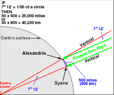
In 33 BC Eratosthenes proved the Earth was a globe, and fairly accurately calculated the circumference (see 3rd picture below)..
Do you finally get that or not?
>>>>>>>>>>>>>>>>>>>>>>>>>>>>>>>>>>>>>>>>>>>>>>>>>
Fact check = You FAIL
Your video is a comical display of mathematical errors, one after the other.
The entire video is an expression of your personal opinion. You presented Zero scientific evidence to back up your words.
What have you been smoking?
Whats even worse, is that your calculations are way off. You need to go back to geometry class.
>>>>>>>>>>>>>>>>>>>>>>>>>>>>>>>>>>>>>>>>>>>>>>>>>
Fact:
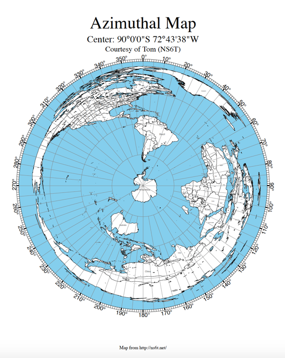
Because the Gleason map is a 2D construct, and as such angular 3D measurements (i.e., latitude and longitude) are not applicable, they should not be used on it.
All northern & southern hemisphere land masses are distorted and not correctly represented on the Gleason map.
As an example, Australia is way way way to big.
In a 2D world locations are specified by Cartesian Coordinates (x and y) axis only.
So the city of New York, as an example, would be specified as...
2D flat Earth coordinates for New York city...
X = 3,464 miles due west of Greenwich, England
Y = 3,245 miles due south of the North Pole
(3D New York City/Coordinates are 40.7128° N, 74.0059° W)
>>>>>>>>>>>>>>>>>>>>>>>>>>>>>>>>>>>>>>>>>>>>>>>>>
Fact check = Correct
Gleason map proves the Earth IS NOT FLAT.
To start out...
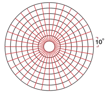
What are the properties of a simple flat geometric circle, of various radii and circumference, at 10 degree angle sweeps?
Using 0 demarcation as the north pole
Using 90 demarcation as the equator
Using 180 demarcation as the south pole limit, outer edge of the flat earth
Based on a sphere with radius 3,959 miles...
table key...
Demarcation, radius, circumference, a 10° sweep covers xx miles
demarc radius circumference 10° sweep in miles
0 0 0 0.0
10 220 1,382 38.4
20 440 2,765 76.8
30 660 4,147 115.2
40 880 5,529 153.6
50 1,100 6,912 192.0
60 1,320 8,294 230.4
70 1,540 9,676 268.8
80 1,760 11,058 307.2
90 1,980 12,441 345.6
100 2,199 13,817 383.8
110 2,419 15,199 422.2
120 2,639 16,581 460.6
130 2,859 17,964 499.0
140 3,079 19,346 537.4
150 3,299 20,728 575.8
160 3,519 22,110 614.2
170 3,739 23,493 652.6
180 3,959 24,875 691.0
So for example. at the Earth's equator (90 demarcation), the radius of that circle is 1,980 miles. the circumference is 12,441 miles, and 10 degrees of angle sweep is equivalent to 345.6 miles in length.
As you can plainly see, the further south one travels on a flat Earth map, the same angle sweep covers greater and greater distance (as picture 1 below clearly shows).
Sidney Australia
(3D Sidney/Coordinates 33.8688° S, 151.2093° E)
Where Sidney Australia is on a flat Earth map, 10 degrees of angle = 475.9 miles
1° of actual angle = 47.59 miles
- - -
Lets now compare the reality of Australia on our globe Earth to flat Earth Gleason map calculation...
west Perth Australia
(31.9505° S, 115.8605° E)
east Brisbane Australia
(27.4698° S, 153.0251° E)
... so Australia spans (153.0251° - 115.8605°) = 37° on actual longitude
From Perth WA, Australia To Brisbane QLD, Australia = 2,681 miles
BUT, on the Gleason flat Earth map it would be...
(37° on actual longitude) * (47.59 miles per degrees) = 1761 miles - which does no match the actual width of Australia on our true globe Earth
Conclusion = Gleason flat Earth map IS WRONG.
- - - - - - - - - - - - - - - - - - - - - - -
Lets do the same calculations for USA, North America;
New York City/Coordinates
40.7128° N, 74.0059° W
Crescent City California
41.7558° N, 124.2026° W
Actual real world difference in longitude = 124.2026° - 74.0059° = 50.2°
Actual real world travel distance = 3,011 miles.
So now on a flat Earth...
Calculate how many miles is the 50.2° degree span in longitude, at that latitude
(41.23° average latitude of both cities) using simple geometry (circle and radius)...
What percentage is that in terms of flat Earth diameter/radius?
(90 - 41.2) = 48.8 demarcation unites from flat Earth North Pole center to USA (New York - Crescent City) latitude line.
North pole to equator to South pole = 180 degrees.
(48.8 / 180) * 3959 miles = 0.27 * 3959 miles = 1069 miles
= from the North Pole as flat Earth circle radius
A circle with radius 1069 miles has a circumference of = 6717 miles
1° of longitude at on that circle would be (6717 / 360) = 18.6 miles
Total flat Earth calculated diameter of the USA = 50.2 * 18.6 miles = 934 miles
Actual distance from New York City to Crescent City California = 3,011 miles
Conclusion = Gleason and flat Earth map = FAIL
Off by a factor of more than 4
>>>>>>>>>>>>>>>>>>>>>>>>>>>>>>>>>>>>>>>>>>>>>>>>>
Fact check:
Degrees of latitude are always 60 nautical miles apart.
A nautical mile is based on the circumference of the earth, and is equal to one minute of LATITUDE. It is slightly more than a statute (land measured) mile (1 nautical mile = 1.1508 statute miles). Nautical miles are used for charting and navigating.
1 nautical mile = 6,076.11549 . . . feet
1 statute mile = 5,280 feet
Fact check = Your calcs FAIL Big Time...
The distance between degrees of LONGITUDE is about 60 nautical miles at the equator. It is less further north or south as the longitude lines converge towards the poles
Here is the correct formula you should be using to get proper degree/distances (LONGITUDE equivalent) on our globe Earth.
Formula for the calculation...
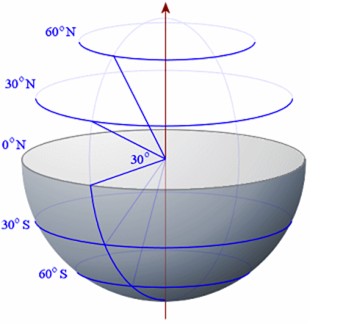
Tangent plane of a sphere calculation:
R = COS(RADIANS(latitude in degrees)) * 3959
...when radius of the Earth = 3,959 statute miles
Arctic Circle...
At latitude 66.57° north of the Equator
Radius of sphere tangent = 1574 statute miles
Diameter of sphere tangent = 3128 statute miles
Circumference of sphere tangent at that latitude = 9,886 statute miles.
One degree of longitude at that latitude = 27.46 statute miles
Tropic of Cancer...
At latitude 23.5° north
Radius of sphere tangent = 3631 statute miles
Diameter of sphere tangent = 7261 statute miles
Circumference of sphere tangent at that latitude = 22,800 statute miles.
One degree of longitude at that latitude = 63.33 statute miles
New York City...
At latitude 40.71° north
Radius of sphere tangent = 3001 statute miles
Diameter of sphere tangent = 6002 statute miles
Circumference of sphere tangent at that latitude = 18,846 statute miles.
One degree of longitude at that latitude = 52.35 statute miles
Equator...
At latitude 0°
Radius of sphere tangent = 3959 statute miles
Diameter of sphere tangent = 7918 statute miles
Circumference of sphere tangent at that latitude = 24,863 statute miles.
One degree of longitude at that latitude = 69.06 statute miles
Tropic of Capricorn...
At latitude 23.5° south
Radius of sphere tangent = 3631 statute miles
Diameter of sphere tangent = 7261 statute miles
Circumference of sphere tangent at that latitude = 22,800 statute miles.
One degree of longitude at that latitude = 63.33 statute miles
Sidney Australia...
At latitude 33.87° south
Radius of sphere tangent = 3287 statute miles
Diameter of sphere tangent = 6574 statute miles
Circumference of sphere tangent at that latitude = 20,643 statute miles.
One degree of longitude at that latitude = 57.34 statute miles
Antarctic Circle...
At latitude 66.57° south of the Equator
Radius of sphere tangent = 1574 statute miles
Diameter of sphere tangent = 3128 statute miles
Circumference of sphere tangent at that latitude = 9,886 statute miles.
One degree of longitude at that latitude = 27.46 statute miles
Grand conclusion - the Gleason flat Earth map IS WRONG, and so are you video calculations.
Published on – April 2, 2017
Discussion at - https://www.youtube.com/channel/UC7ipUKERU0tzYFxALJBli4A/discussion
Video at - https://www.youtube.com/watch?v=SSf-QaHUZ8s
Our home page all articles - http://flatearthlunacy.com
kind regards, JonahTheScientist
>>>>>>>>>>>>>>>>>>>>>>>>>>>>>>>>>>>>>>>>>>>>>>>>>
- - - - - - - - - -
(http://www.intmath.com/vectors/img/sphere5.png)
(http://www.geo.hunter.cuny.edu/~jochen/GTECH201/Lectures/Lec6concepts/Datums/Determining%20the%20earths%20size_files/image001.gif)
Picture 1..
Picture 2..
Picture 3..
Picture 4..